
Faire un don
Équipez-vous pour votre prochaine aventure :
En tant que Partenaire Amazon, ce site perçoit une commission sur les achats éligibles sans surcoût pour vous.
Carte topographique Kedarnath
Cliquez sur la carte pour afficher l’altitude.
Faire un don
Équipez-vous pour votre prochaine aventure :
En tant que Partenaire Amazon, ce site perçoit une commission sur les achats éligibles sans surcoût pour vous.
Kedarnath
La localité est situé dans la haute vallée de la Mandakini à plus de 3000 mètres d'altitude. Le climat est relativement frais et glacial, le printemps et l'été sont courts alors que l'hiver s'étale sur une période allant du mois de novembre jusqu'au mois d'avril. Du fait de son accessibilité limité, la vallée de Kedarnath est fréquentable seulement une partie de l'année, de la fête d'Akshaya Tritiya (fin avril/début mai) jusqu'à la fête de Bhau-Bheej (dernière festivité de Diwali, qui a lieu généralement entre fin octobre/début novembre).
Faire un don
Équipez-vous pour votre prochaine aventure :
En tant que Partenaire Amazon, ce site perçoit une commission sur les achats éligibles sans surcoût pour vous.
À propos de cette carte
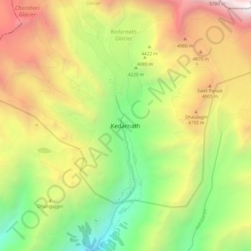
Nom : Carte topographique Kedarnath, altitude, relief.
Lieu : Kedarnath, Ukhimath, Rudraprayag, Uttarakhand, Inde (30.69389 79.02691 30.77389 79.10691)
Altitude moyenne : 4 208 m
Altitude minimum : 2 731 m
Altitude maximum : 6 044 m
Faire un don
Équipez-vous pour votre prochaine aventure :
En tant que Partenaire Amazon, ce site perçoit une commission sur les achats éligibles sans surcoût pour vous.