
Faire un don
Équipez-vous pour votre prochaine aventure :
En tant que Partenaire Amazon, ce site perçoit une commission sur les achats éligibles sans surcoût pour vous.
Carte topographique Cluj-Napoca
Cliquez sur la carte pour afficher l’altitude.
Faire un don
Équipez-vous pour votre prochaine aventure :
En tant que Partenaire Amazon, ce site perçoit une commission sur les achats éligibles sans surcoût pour vous.
Cluj-Napoca
Occupant notamment la plaine alluviale du Petit Someș, Cluj s’étend aussi sur les pentes des chaînes collinaires qui la délimitent au nord et au sud. Ainsi, le Sud de la ville occupe-t-il une bonne partie du versant nord de la longue colline de Feleac (qui atteint 825 mètres au sommet Măgura Sălicei), alors qu’au sud-ouest elle s’étend sur une partie de la moins imposante colline de Făget. Le Nord de la ville occupe les versants sud de plusieurs collines, telles que Dealul Hoiei (506 m), Dealul Gârbăului (570 m), Dealul Lombului (684 m), Dealul Melcului (617 m), Dealul Techintău (633 m)… Cluj englobe aussi plusieurs autres collines de plus faible altitude.
Faire un don
Équipez-vous pour votre prochaine aventure :
En tant que Partenaire Amazon, ce site perçoit une commission sur les achats éligibles sans surcoût pour vous.
À propos de cette carte
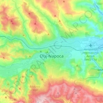
Nom : Carte topographique Cluj-Napoca, altitude, relief.
Lieu : Cluj-Napoca, Zona Metropolitană Cluj, Cluj, Roumanie (46.68997 23.49924 46.86183 23.71833)
Altitude moyenne : 480 m
Altitude minimum : 307 m
Altitude maximum : 829 m
Faire un don
Équipez-vous pour votre prochaine aventure :
En tant que Partenaire Amazon, ce site perçoit une commission sur les achats éligibles sans surcoût pour vous.
Autres cartes topographiques
Cliquez sur une carte pour visualiser sa topographie, son altitude et son relief.
Faire un don
Équipez-vous pour votre prochaine aventure :
En tant que Partenaire Amazon, ce site perçoit une commission sur les achats éligibles sans surcoût pour vous.