
Faire un don
Équipez-vous pour votre prochaine aventure :
En tant que Partenaire Amazon, ce site perçoit une commission sur les achats éligibles sans surcoût pour vous.
Carte topographique Lingshed
Cliquez sur la carte pour afficher l’altitude.
Faire un don
Équipez-vous pour votre prochaine aventure :
En tant que Partenaire Amazon, ce site perçoit une commission sur les achats éligibles sans surcoût pour vous.
À propos de cette carte
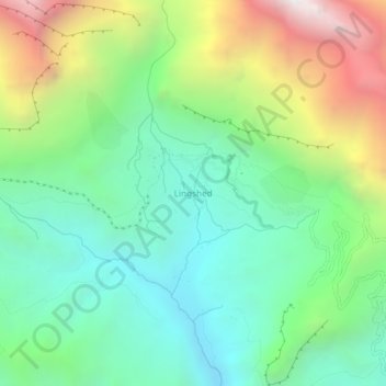
Nom : Carte topographique Lingshed, altitude, relief.
Lieu : Lingshed, Sham Valley, Inde (33.88384 76.80465 33.92384 76.84465)
Altitude moyenne : 4 209 m
Altitude minimum : 3 574 m
Altitude maximum : 5 487 m
Faire un don
Équipez-vous pour votre prochaine aventure :
En tant que Partenaire Amazon, ce site perçoit une commission sur les achats éligibles sans surcoût pour vous.
Autres cartes topographiques
Cliquez sur une carte pour visualiser sa topographie, son altitude et son relief.
New Delhi
Située dans le Nord de l'Inde, la capitale indienne se trouve à 238 km au nord-est de Jaipur, à 691 km au sud-est d'Islamabad, à 778 km au nord-est d'Ahmedabad, à 800 km à l'ouest de Kathmandou, à 1 151 km au nord-nord-est de Bombay, à 1 303 km à l'ouest-nord-ouest de Calcutta et à 6 588 km à l'est…
Altitude moyenne : 230 m
Faire un don
Équipez-vous pour votre prochaine aventure :
En tant que Partenaire Amazon, ce site perçoit une commission sur les achats éligibles sans surcoût pour vous.
Faire un don
Équipez-vous pour votre prochaine aventure :
En tant que Partenaire Amazon, ce site perçoit une commission sur les achats éligibles sans surcoût pour vous.
Sikkim
Le Sikkim, État en forme de pouce enfoncé entre le Tibet, le Népal et le Bhoutan, est caractérisé par un relief globalement montagneux. Presque tout l'État est vallonné, avec une altitude allant de 280 à 8 598 mètres. Le sommet du Kangchenjunga (8 598 m), situé à cheval sur le Sikkim et le Népal,…
Altitude moyenne : 3 784 m
Bombay
Bombay est située dans l'ouest de l'Inde, à l'embouchure du fleuve Ulhas, sur la côte occidentale du pays, appelée à cette latitude côte de Konkan. La ville, qui borde la mer d'Arabie, s'est développée sur l'île de Salsette, dont la partie nord appartient au district de Thane. L'altitude de la ville…
Altitude moyenne : 18 m
Faire un don
Équipez-vous pour votre prochaine aventure :
En tant que Partenaire Amazon, ce site perçoit une commission sur les achats éligibles sans surcoût pour vous.
Bangalore
Inde > Karnataka > Bangalore North
Bangalore bénéficie d'un climat tropical de mousson avec une saison des pluies bien marquée. La ville jouit d'un climat moins étouffant que la majeure partie des villes indiennes en raison de son altitude assez élevée. Cependant des vagues de forte chaleur ne sont pas à exclure. Le mois le plus froid…
Altitude moyenne : 886 m
Gujarat
Le relief est peu accentué dans la plupart de l'État. Le plus haut sommet de la région est le mont Girnar, qui culmine à 1 030 mètres d'altitude, au-dessus de la région de Junagadh. Les deux principales chaînes montagneuses de la région sont les Ghâts occidentaux et l'Aravalli, qui s'étendent…
Altitude moyenne : 138 m
Bombay
Bombay est située dans l'ouest de l'Inde, à l'embouchure du fleuve Ulhas, sur la côte occidentale du pays, appelée à cette latitude côte de Konkan. La ville, qui borde la mer d'Arabie, s'est développée sur l'île de Salsette, dont la partie nord appartient au district de Thane. L'altitude de la ville…
Altitude moyenne : 18 m
Faire un don
Équipez-vous pour votre prochaine aventure :
En tant que Partenaire Amazon, ce site perçoit une commission sur les achats éligibles sans surcoût pour vous.
Faire un don
Équipez-vous pour votre prochaine aventure :
En tant que Partenaire Amazon, ce site perçoit une commission sur les achats éligibles sans surcoût pour vous.
Hyderabad
Inde > Telangana > Bahadurpura mandal
Hyderabad est bâtie au nord du Deccan sur les rives de la rivière Musi, à une altitude de 542 m. Elle possède de nombreux sagar (lacs) comme l'Osman Sagar, l'Hussein Sagar ou l'Himayat Sagar pour citer les plus grands des 140 lacs de la ville.
Altitude moyenne : 549 m
Faire un don
Équipez-vous pour votre prochaine aventure :
En tant que Partenaire Amazon, ce site perçoit une commission sur les achats éligibles sans surcoût pour vous.
Faire un don
Équipez-vous pour votre prochaine aventure :
En tant que Partenaire Amazon, ce site perçoit une commission sur les achats éligibles sans surcoût pour vous.
Nubra
La rivière Shyok rencontre la rivière Noubra (ou rivière Siachan) pour former une grande vallée qui sépare les chaînes du Ladakh et du Karakoram. La rivière Shyok est un affluent de la rivière Indus. L'altitude moyenne de la vallée est de plus de 3 000 m. Le moyen commun d'accéder à cette vallée…
Altitude moyenne : 4 978 m
Tamil Nadu
Le Tamil Nadu est essentiellement dominé par un climat tropical sec et humide, dépendant de la mousson d'hiver. Une part importante du territoire (particulièrement l'arrière-pays) connait un climat semi-aride chaud. En marge, les régions d'altitudes élevées (Nilgiris, Monts Palnis) présentent un climat tempéré.
Altitude moyenne : 253 m
Faire un don
Équipez-vous pour votre prochaine aventure :
En tant que Partenaire Amazon, ce site perçoit une commission sur les achats éligibles sans surcoût pour vous.
Faire un don
Équipez-vous pour votre prochaine aventure :
En tant que Partenaire Amazon, ce site perçoit une commission sur les achats éligibles sans surcoût pour vous.
Faire un don
Équipez-vous pour votre prochaine aventure :
En tant que Partenaire Amazon, ce site perçoit une commission sur les achats éligibles sans surcoût pour vous.
Île Andaman du Nord
Inde > Îles Andaman-et-Nicobar > Diglipur
Andaman du Nord est la plus grande des îles Andaman, avec une superficie de 1 376 km². Elle possède le point culminant de l'archipel, Saddle Peak, à 732 mètres d'altitude.
Altitude moyenne : 12 m
Faire un don
Équipez-vous pour votre prochaine aventure :
En tant que Partenaire Amazon, ce site perçoit une commission sur les achats éligibles sans surcoût pour vous.
Faire un don
Équipez-vous pour votre prochaine aventure :
En tant que Partenaire Amazon, ce site perçoit une commission sur les achats éligibles sans surcoût pour vous.
Faire un don
Équipez-vous pour votre prochaine aventure :
En tant que Partenaire Amazon, ce site perçoit une commission sur les achats éligibles sans surcoût pour vous.
Himachal Pradesh
Sa superficie est de 55 673 km2, il est encadré par les territoires de l'union indienne du Jammu-et-Cachemire et Ladakh au nord, et par les États indiens du Pendjab à l'ouest, du Haryana et de l'Uttar Pradesh au sud, de l'Uttarakhand au sud-est et par le Tibet (région de la Chine) à l'est. Situé dans…
Altitude moyenne : 2 682 m
Keoladeo Ghana National Park
Inde > Rajasthan > Bharatpur Tehsil > Chak Darapur No 1
Altitude moyenne : 177 m
Rishikesh
La ville se situe à 350 m d'altitude et elle est traversée par le Gange. Elle se trouve à 250 kilomètres par la route, de Gaumukh, où le Gange prend sa source.
Altitude moyenne : 808 m
Faire un don
Équipez-vous pour votre prochaine aventure :
En tant que Partenaire Amazon, ce site perçoit une commission sur les achats éligibles sans surcoût pour vous.
Jammu-et-Cachemire
Le Jammu-et-Cachemire abrite plusieurs vallées telles que la vallée du Cachemire, la vallée du Tawi, la vallée du Chenab, la vallée du Poonch, la vallée du Sind et la vallée du Lidder. L'Himalaya sépare la vallée du Cachemire du plateau tibétain tandis que la chaîne Pir Panjal, qui entoure la…
Altitude moyenne : 2 430 m
Faire un don
Équipez-vous pour votre prochaine aventure :
En tant que Partenaire Amazon, ce site perçoit une commission sur les achats éligibles sans surcoût pour vous.
Faire un don
Équipez-vous pour votre prochaine aventure :
En tant que Partenaire Amazon, ce site perçoit une commission sur les achats éligibles sans surcoût pour vous.
Faire un don
Équipez-vous pour votre prochaine aventure :
En tant que Partenaire Amazon, ce site perçoit une commission sur les achats éligibles sans surcoût pour vous.
Faire un don
Équipez-vous pour votre prochaine aventure :
En tant que Partenaire Amazon, ce site perçoit une commission sur les achats éligibles sans surcoût pour vous.
Faire un don
Équipez-vous pour votre prochaine aventure :
En tant que Partenaire Amazon, ce site perçoit une commission sur les achats éligibles sans surcoût pour vous.
Faire un don
Équipez-vous pour votre prochaine aventure :
En tant que Partenaire Amazon, ce site perçoit une commission sur les achats éligibles sans surcoût pour vous.
Faire un don
Équipez-vous pour votre prochaine aventure :
En tant que Partenaire Amazon, ce site perçoit une commission sur les achats éligibles sans surcoût pour vous.
Kargil district old
À une altitude moyenne de 2 676 mètres, la ville se situe au bord des rives du Suru.
Altitude moyenne : 4 214 m
Jammu-et-Cachemire
Le Jammu-et-Cachemire abrite plusieurs vallées telles que la vallée du Cachemire, la vallée du Tawi, la vallée du Chenab, la vallée du Poonch, la vallée du Sind et la vallée du Lidder. L'Himalaya sépare la vallée du Cachemire du plateau tibétain tandis que la chaîne Pir Panjal, qui entoure la…
Altitude moyenne : 2 430 m
Faire un don
Équipez-vous pour votre prochaine aventure :
En tant que Partenaire Amazon, ce site perçoit une commission sur les achats éligibles sans surcoût pour vous.
Pendjab
La majeure partie du Pendjab occupe une plaine alluviale fertile parcourue par de nombreuses rivières et un important réseau de canaux d'irrigation. Au nord-est de l'État se trouve la chaîne montagneuse du Shivalik, qui forme les contreforts de l'Himalaya, tandis que dans le nord de l'État, le district de…
Altitude moyenne : 477 m
Faire un don
Équipez-vous pour votre prochaine aventure :
En tant que Partenaire Amazon, ce site perçoit une commission sur les achats éligibles sans surcoût pour vous.
Sikkim
Le Sikkim, État en forme de pouce enfoncé entre le Tibet, le Népal et le Bhoutan, est caractérisé par un relief globalement montagneux. Presque tout l'État est vallonné, avec une altitude allant de 280 à 8 598 mètres. Le sommet du Kangchenjunga (8 598 m), situé à cheval sur le Sikkim et le Népal,…
Altitude moyenne : 3 784 m
Gange
Il traverse ensuite Haridwar, situé à 300 m d'altitude, et coule à travers la plaine indo-gangétique, perdant peu de dénivelé tout en collectant un certain nombre d'affluents : la Yamuna (1 300 km), la Karnali (1 080 km) à Chapra, le Gandaki (700 km) à Hajipur, la Ramganga (640 km) peu avant Prayagraj,…
Altitude moyenne : 1 673 m
Faire un don
Équipez-vous pour votre prochaine aventure :
En tant que Partenaire Amazon, ce site perçoit une commission sur les achats éligibles sans surcoût pour vous.
Faire un don
Équipez-vous pour votre prochaine aventure :
En tant que Partenaire Amazon, ce site perçoit une commission sur les achats éligibles sans surcoût pour vous.