
Carte topographique Peterborough
Cliquez sur la carte pour afficher l’altitude.
Peterborough
La ville est arrosée par la rivière Nene, qui se jette dans la mer du Nord (à quelque 48 km) au nord-est. L'Hôtel de ville est situé à 118 km au nord du centre de Londres, à Charing Cross. La topographie locale est notoirement plate et de faible altitude, et peut-être à certains endroits située au-dessous du niveau de la mer. La zone connue sous le nom de the Fens tombe à l'est de Peterborough.
À propos de cette carte
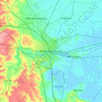
Nom : Carte topographique Peterborough, altitude, relief.
Altitude moyenne : 17 m
Altitude minimum : -19 m
Altitude maximum : 92 m
Autres cartes topographiques
Cliquez sur une carte pour visualiser sa topographie, son altitude et son relief.
Godmanchester
Royaume-Uni > Angleterre > Cambridgeshire > Huntingdonshire > Godmanchester
Altitude moyenne : 22 m
West Wickham
Royaume-Uni > Angleterre > Cambridgeshire > South Cambridgeshire
Altitude moyenne : 103 m
Cambridge
Royaume-Uni > Angleterre > Cambridgeshire
Le climat océanique de la ville, comme la majeure partie du Royaume-Uni, est fortement influencé par le Gulf Stream. Située dans la région la plus sèche de Grande-Bretagne, les précipitations moyennes y sont d'environ 570 mm par an, soit environ la moitié de la moyenne nationale. L'année récente la…
Altitude moyenne : 18 m