Géolocaliser

Carte topographique Ramsgate

Carte interactive

Cliquez sur la carte pour afficher l’altitude.

À propos de cette carte

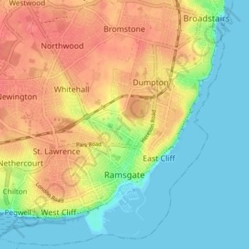
Nom : Carte topographique Ramsgate, altitude, relief.

Lieu : Ramsgate, Thanet, Kent, England, United Kingdom (51.32210 1.37687 51.36087 1.44107)

Altitude moyenne : 25 m

Altitude minimum : 0 m

Altitude maximum : 55 m

In 2017 Ramsgate was chosen as one of the first ten Heritage Action Zones (HAZ) by Historic England, with the aim of stimulating economic growth using Ramsgate's historic environment as a catalyst. Part of this project included a Historic Landscape Characterisation Study which assessed and mapped the patterns of historic character in the town, using geological and topographical surveys, and covering aspects from the Neolithic, medieval, Georgian, Victorian, and through to the First and Second World War periods.

Wikipedia (CC-BY-SA 3.0)

Autres cartes topographiques

Cliquez sur une carte pour visualiser sa topographie, son altitude et son relief.

St Nicholas-at-Wade

United Kingdom > England > Kent > Thanet

St Nicholas-at-Wade, Thanet, Kent, England, United Kingdom

Altitude moyenne : 8 m

Margate

United Kingdom > England > Kent > Thanet

Margate, Thanet, Kent, England, United Kingdom

Altitude moyenne : 22 m