
Faire un don
Équipez-vous pour votre prochaine aventure :
En tant que Partenaire Amazon, ce site perçoit une commission sur les achats éligibles sans surcoût pour vous.
Carte topographique Penyagolosa
Cliquez sur la carte pour afficher l’altitude.
Faire un don
Équipez-vous pour votre prochaine aventure :
En tant que Partenaire Amazon, ce site perçoit une commission sur les achats éligibles sans surcoût pour vous.
Penyagolosa
Penyagolosa (espagnol : Peñagolosa) est une montagne située dans la comarque d'Alcalatén, dans la Communauté valencienne, en Espagne. Elle fait partie du Système ibérique et culmine à 1 815 mètres d'altitude.
Faire un don
Équipez-vous pour votre prochaine aventure :
En tant que Partenaire Amazon, ce site perçoit une commission sur les achats éligibles sans surcoût pour vous.
À propos de cette carte
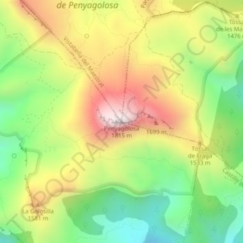
Nom : Carte topographique Penyagolosa, altitude, relief.
Altitude moyenne : 1 417 m
Altitude minimum : 1 092 m
Altitude maximum : 1 796 m
Faire un don
Équipez-vous pour votre prochaine aventure :
En tant que Partenaire Amazon, ce site perçoit une commission sur les achats éligibles sans surcoût pour vous.