Carte topographique Yamanouchi
Carte interactive
Cliquez sur la carte pour afficher l’altitude.
À propos de cette carte
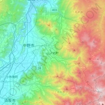
Nom : Carte topographique Yamanouchi, altitude, relief.
Lieu : Yamanouchi, Shimotakai County, Nagano Prefecture, Japan (36.66571 138.38338 36.82465 138.64215)
Altitude moyenne : 942 m
Altitude minimum : 305 m
Altitude maximum : 2 303 m
Shimotakai District, in northern mountainous Nagano Prefecture, comprises Yamanouchi town, Kijimadaira Village, and Nozawaonsen Village. Yamanouchi is the largest of these. More than 90% of Yamanouchi is covered by mountains and forests. The town measures approximately 39 kilometers east-west and 12 kilometers north-south (266 square kilometers), and has an elevation ranging from 424 meters to 2341 meters. The surrounding area is known for its forest therapy.
Autres cartes topographiques
Cliquez sur une carte pour visualiser sa topographie, son altitude et son relief.
Nozawaonsen
Nozawaonsen, Shimotakai County, Nagano Prefecture, Chubu Region, 389-2502, Japan
Altitude moyenne : 710 m
Biwa Lake
Japan > Shimotakai County > Yamanouchi
Biwa Lake, Yamanouchi, Shimotakai County, Nagano Prefecture, Japan
Altitude moyenne : 1 368 m