
Faire un don
Équipez-vous pour votre prochaine aventure :
En tant que Partenaire Amazon, ce site perçoit une commission sur les achats éligibles sans surcoût pour vous.
Carte topographique تحصیل مستوج
Cliquez sur la carte pour afficher l’altitude.
Faire un don
Équipez-vous pour votre prochaine aventure :
En tant que Partenaire Amazon, ce site perçoit une commission sur les achats éligibles sans surcoût pour vous.
À propos de cette carte
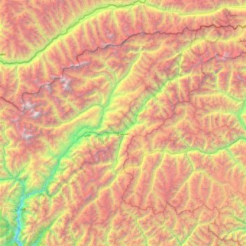
Nom : Carte topographique تحصیل مستوج, altitude, relief.
Altitude moyenne : 4 143 m
Altitude minimum : 1 426 m
Altitude maximum : 7 626 m
Faire un don
Équipez-vous pour votre prochaine aventure :
En tant que Partenaire Amazon, ce site perçoit une commission sur les achats éligibles sans surcoût pour vous.
Autres cartes topographiques
Cliquez sur une carte pour visualiser sa topographie, son altitude et son relief.
Nowshak
Pakistan > Khyber Pakhtunkhwa > District de Chitrâl > تحصیل تورکھو-موڑکھو
Le Nowshak, ou Noshaq, culminant à 7 492 m d'altitude, est une montagne entre l'Afghanistan, dont il est le point culminant, et le Pakistan, ainsi que le deuxième plus haut sommet de l’Hindou Kouch après le Tirich Mir (7 690 m).
Altitude moyenne : 6 868 m
Karambar-Pass
Pakistan > Khyber Pakhtunkhwa > District de Chitrâl > تحصیل مستوج
Altitude moyenne : 4 443 m
Tirich Mir
Pakistan > Khyber Pakhtunkhwa > District de Chitrâl > تحصیل تورکھو-موڑکھو
Le Tirich Mir est un sommet du Pakistan s'élevant à 7 708 mètres d'altitude dans la province de Khyber Pakhtunkhwa et constituant le point culminant de l'Hindou Kouch. Il est entouré de glaciers. Des alpinistes norvégiens ont réalisé les premières ascensions de la cime principale et de la cime…
Altitude moyenne : 6 802 m
Faire un don
Équipez-vous pour votre prochaine aventure :
En tant que Partenaire Amazon, ce site perçoit une commission sur les achats éligibles sans surcoût pour vous.
Hindu Kush
Pakistan > Khyber Pakhtunkhwa > District de Chitrâl > تحصیل چترال
Altitude moyenne : 5 281 m