
Faire un don
Équipez-vous pour votre prochaine aventure :
En tant que Partenaire Amazon, ce site perçoit une commission sur les achats éligibles sans surcoût pour vous.
Carte topographique Mount Chōkai
Cliquez sur la carte pour afficher l’altitude.
Faire un don
Équipez-vous pour votre prochaine aventure :
En tant que Partenaire Amazon, ce site perçoit une commission sur les achats éligibles sans surcoût pour vous.
Mount Chōkai
Mount Chōkai is shared by two municipalities in Akita Prefecture and four municipalities Yamagata Prefecture; however, its peak is located in Yuza, on the Yamagata side of the border. It is therefore the highest peak in Yamagata, and the second highest in the Tōhoku region after Mt. Hiuchigatake (altitude 2,356 m). The highest elevation of Mount Chōkai within Akita Prefecture has an altitude of 1,775 meters, and thus the mountain is also the highest in Akita Prefecture. From the summit, it is possible to see the Shirakami Mountains and Mount Iwaki to the north, Sado Island to the south and the Pacific Ocean to the east.
Faire un don
Équipez-vous pour votre prochaine aventure :
En tant que Partenaire Amazon, ce site perçoit une commission sur les achats éligibles sans surcoût pour vous.
À propos de cette carte
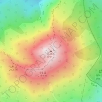
Nom : Carte topographique Mount Chōkai, altitude, relief.
Lieu : Mount Chōkai, Yuza, Akumi County, Yamagata Prefecture, Japan (39.09920 140.05030 39.09930 140.05040)
Altitude moyenne : 1 808 m
Altitude minimum : 1 387 m
Altitude maximum : 2 221 m
Faire un don
Équipez-vous pour votre prochaine aventure :
En tant que Partenaire Amazon, ce site perçoit une commission sur les achats éligibles sans surcoût pour vous.