
Faire un don
Équipez-vous pour votre prochaine aventure :
En tant que Partenaire Amazon, ce site perçoit une commission sur les achats éligibles sans surcoût pour vous.
Carte topographique Leadville
Cliquez sur la carte pour afficher l’altitude.
Faire un don
Équipez-vous pour votre prochaine aventure :
En tant que Partenaire Amazon, ce site perçoit une commission sur les achats éligibles sans surcoût pour vous.
Leadville
Leadville est une ville des États-Unis située à 3 000 m d'altitude, à 120 kilomètres à l'ouest de Denver, dans l'État du Colorado. Elle se situe à moins de quatre kilomètres de la source de l'Arkansas. C'est le siège du comté de Lake.
Faire un don
Équipez-vous pour votre prochaine aventure :
En tant que Partenaire Amazon, ce site perçoit une commission sur les achats éligibles sans surcoût pour vous.
À propos de cette carte
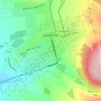
Nom : Carte topographique Leadville, altitude, relief.
Altitude moyenne : 3 106 m
Altitude minimum : 3 023 m
Altitude maximum : 3 247 m
Faire un don
Équipez-vous pour votre prochaine aventure :
En tant que Partenaire Amazon, ce site perçoit une commission sur les achats éligibles sans surcoût pour vous.