
Faire un don
Équipez-vous pour votre prochaine aventure :
En tant que Partenaire Amazon, ce site perçoit une commission sur les achats éligibles sans surcoût pour vous.
Carte topographique Michigan
Cliquez sur la carte pour afficher l’altitude.
Faire un don
Équipez-vous pour votre prochaine aventure :
En tant que Partenaire Amazon, ce site perçoit une commission sur les achats éligibles sans surcoût pour vous.
Michigan
L'État est formé par deux péninsules isolées par le détroit de Mackinac. La péninsule supérieure est une pénéplaine où affleure le bouclier canadien. Elle culmine à 603 mètres d'altitude (mont Arvon) et possède des chutes d'eau pittoresques, dont les chutes Tahquamenon. Au nord, dans le lac Supérieur, se situe le Parc national de l'Isle Royale. La péninsule inférieure est formée de basses collines. Façonnée par les glaciers quaternaires, elle est aujourd'hui parsemée d'une multitude de petits cours d'eau et de lacs intérieurs. Le climat est continental humide. Les étés sont chauds et humides, et les hivers sont froids avec beaucoup de neige, particulièrement dans le Nord de l'État et sur la rive de lac Michigan. Les forêts (pins, érables, hêtres, chênes) couvrent près de la moitié du territoire du Michigan.
Faire un don
Équipez-vous pour votre prochaine aventure :
En tant que Partenaire Amazon, ce site perçoit une commission sur les achats éligibles sans surcoût pour vous.
À propos de cette carte
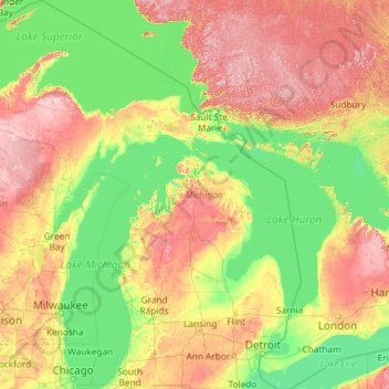
Nom : Carte topographique Michigan, altitude, relief.
Lieu : Michigan, États-Unis d'Amérique (41.69613 -90.41862 48.30606 -82.12281)
Altitude moyenne : 259 m
Altitude minimum : 169 m
Altitude maximum : 653 m
Faire un don
Équipez-vous pour votre prochaine aventure :
En tant que Partenaire Amazon, ce site perçoit une commission sur les achats éligibles sans surcoût pour vous.
Autres cartes topographiques
Cliquez sur une carte pour visualiser sa topographie, son altitude et son relief.
Cedar Glen Lakes
États-Unis d'Amérique > New Jersey > Ocean County > Manchester Township
Altitude moyenne : 47 m
Mont Washington
États-Unis d'Amérique > New Hampshire > Coös County
Le mont Washington est le point culminant du Nord-Est des États-Unis avec une altitude de 1 917 mètres. Il se situe dans les montagnes Blanches dans le comté de Coös. La plus grande partie du mont se situe dans la forêt nationale de White Mountain et le parc d'État du Mont-Washington.
Altitude moyenne : 1 568 m
Alamo
États-Unis d'Amérique > Nevada > Lincoln County
Alamo est une ville non incorporée du comté de Lincoln, dans l'État du Nevada aux États-Unis. Elle est située dans la vallée Pahranagat, à 1 051 m d'altitude, à 140 km au nord de Las Vegas.
Altitude moyenne : 1 092 m
Faire un don
Équipez-vous pour votre prochaine aventure :
En tant que Partenaire Amazon, ce site perçoit une commission sur les achats éligibles sans surcoût pour vous.
Montagnes Rocheuses
États-Unis d'Amérique > Wyoming > Teton County
Leur altitude varie entre 1 500 m près des hautes plaines et 4 399 m au mont Elbert dans le Colorado. Leur largeur est comprise entre 120 et 650 km. Elles prennent une forme oblongue, étendue en latitude sur plusieurs milliers de kilomètres.
Altitude moyenne : 2 292 m
Faire un don
Équipez-vous pour votre prochaine aventure :
En tant que Partenaire Amazon, ce site perçoit une commission sur les achats éligibles sans surcoût pour vous.
Appalaches
États-Unis d'Amérique > Caroline du Nord > Yancey County
La chaîne des Appalaches occupe dans sa plus grande partie le territoire américain et déborde sur le sud-est du Canada. Elle s'étend entre la latitude 49°N (monts Chic-Chocs au Québec, Canada) et la latitude 32°N (Alabama, États-Unis). Le point culminant de la partie canadienne du massif est le mont…
Altitude moyenne : 1 463 m
Wateford Woods Park
États-Unis d'Amérique > Wisconsin > Racine County > Town of Waterford
Altitude moyenne : 245 m
Grand Canyon
États-Unis d'Amérique > Arizona > Coconino County
Le climat est marqué par l'aridité et l'altitude. Les précipitations annuelles sur South Rim sont de 380 mm. Les températures varient entre le nord (plus froid car plus élevé) et le sud du parc. Elles sont différentes selon que l'on se trouve sur le plateau ou au fond du canyon : l'été est…
Altitude moyenne : 1 023 m
Faire un don
Équipez-vous pour votre prochaine aventure :
En tant que Partenaire Amazon, ce site perçoit une commission sur les achats éligibles sans surcoût pour vous.
Los Angeles
États-Unis d'Amérique > Californie > Los Angeles County
L'altitude maximale sur la commune est de 1 548 m au Sister Elsie Peak. Le territoire de la ville de Los Angeles est si vaste qu'elle est généralement divisée en plusieurs grands secteurs : Downtown Los Angeles (Central L.A), Eastside, Wilshire, Hollywood, Northwest, South Los Angeles (anciennement South…
Altitude moyenne : 144 m
Chutes du Niagara
États-Unis d'Amérique > New York > Niagara County > City of Niagara Falls
Pendant et après la fonte de l'inlandsis, les cours d’eau ont dû se frayer un chemin vers le nord-ouest, dans une topographie bouleversée, en incisant de nouveaux lits. La localisation actuelle du canal Welland correspondrait à une ancienne vallée. Les flots provenant des Grands Lacs en amont formèrent…
Altitude moyenne : 173 m
Los Angeles
États-Unis d'Amérique > Californie > Los Angeles County
L'altitude maximale sur la commune est de 1 543 m au Mont Lukens (en). Le territoire de la ville de Los Angeles est si vaste qu'elle est généralement divisée en plusieurs grands secteurs : Downtown Los Angeles (Central L.A), Eastside, Wilshire, Hollywood, Northwest, South Los Angeles (anciennement South…
Altitude moyenne : 144 m
Faire un don
Équipez-vous pour votre prochaine aventure :
En tant que Partenaire Amazon, ce site perçoit une commission sur les achats éligibles sans surcoût pour vous.
Faire un don
Équipez-vous pour votre prochaine aventure :
En tant que Partenaire Amazon, ce site perçoit une commission sur les achats éligibles sans surcoût pour vous.
Grand Canyon
États-Unis d'Amérique > Arizona > Coconino County
Le climat est marqué par l'aridité et l'altitude. Les précipitations annuelles sur South Rim sont de 380 mm. Les températures varient entre le nord (plus froid car plus élevé) et le sud du parc. Elles sont différentes selon que l'on se trouve sur le plateau ou au fond du canyon : l'été est…
Altitude moyenne : 1 023 m
Faire un don
Équipez-vous pour votre prochaine aventure :
En tant que Partenaire Amazon, ce site perçoit une commission sur les achats éligibles sans surcoût pour vous.
Erie Canal
États-Unis d'Amérique > New York > Erie County > City of Tonawanda
La première section du canal est ouverte en 1819, et le reste le 26 octobre 1825. Il est à cette époque long de 584 kilomètres, pour une largeur de 12 mètres et une profondeur de 1,20 mètre. 83 écluses, au gabarit de 27 mètres sur 4,50, permettent de compenser la différence d'altitude de 183 mètres…
Altitude moyenne : 177 m
Faire un don
Équipez-vous pour votre prochaine aventure :
En tant que Partenaire Amazon, ce site perçoit une commission sur les achats éligibles sans surcoût pour vous.
Appalaches
États-Unis d'Amérique > Caroline du Nord > Yancey County
La chaîne des Appalaches occupe dans sa plus grande partie le territoire américain et déborde sur le sud-est du Canada. Elle s'étend entre la latitude 49°N (monts Chic-Chocs au Québec, Canada) et la latitude 32°N (Alabama, États-Unis). Le point culminant de la partie canadienne du massif est le mont…
Altitude moyenne : 1 463 m
Goat Rocks
États-Unis d'Amérique > Massachusetts > Dukes County > West Tisbury
Altitude moyenne : 30 m
Monument Valley Navajo Tribal Park
États-Unis d'Amérique > Arizona > Navajo County
Monument Valley connaît un climat désertique avec des hivers froids et des étés chauds. Ces derniers sont toutefois tempérés par l'altitude de la région : alors que la température excède 32 °C durant 54 jours en moyenne par an, elle dépasse rarement 38 °C sur les hauteurs. Les nuits sont fraîches,…
Altitude moyenne : 1 675 m
Faire un don
Équipez-vous pour votre prochaine aventure :
En tant que Partenaire Amazon, ce site perçoit une commission sur les achats éligibles sans surcoût pour vous.
Appalaches
États-Unis d'Amérique > Caroline du Nord > Yancey County
Les Appalaches sont une chaîne de montagnes située dans l'Est de l'Amérique du Nord et s'étendant de Terre-Neuve (Canada), au nord, jusqu'au centre de l'État de l'Alabama, au sud (États-Unis). Elle culmine au mont Mitchell (2 037 mètres) en Caroline du Nord. Les Appalaches canadiennes culminent à 1 270…
Altitude moyenne : 1 463 m
Mount Mansfield
États-Unis d'Amérique > Vermont > Chittenden County > Underhill
Le mont Mansfield (en anglais : Mount Mansfield) est le point culminant du Vermont avec une altitude de 1 339 mètres. C'est aussi le plus haut sommet des montagnes Vertes (Green Mountains). Le mont Mansfield est aussi l'un des trois sommets des montagnes Vertes où une toundra alpine se développe avec sa…
Altitude moyenne : 914 m
Florida Keys
États-Unis d'Amérique > Floride > Comté de Monroe
Les Keys sont un archipel situé à l'extrémité méridionale des États-Unis, dans l'océan Atlantique et dans l'Est du golfe du Mexique. Cette suite d'îles de faible altitude se développe depuis la péninsule de Floride jusqu'au 83e méridien Ouest (passant par Dry Tortugas). L'archipel s'étire depuis…
Altitude moyenne : 0 m
Faire un don
Équipez-vous pour votre prochaine aventure :
En tant que Partenaire Amazon, ce site perçoit une commission sur les achats éligibles sans surcoût pour vous.
Jay Peak
États-Unis d'Amérique > Vermont > Orleans County > Westfield
Le pic Jay (en anglais : Jay Peak), est un sommet de 1 176 mètres d'altitude situé dans la municipalité de Jay, dans le comté d'Orleans au Vermont, dans le Nord-Est des États-Unis, tout près de la frontière avec le Canada.
Altitude moyenne : 838 m
Mount Lee
États-Unis d'Amérique > Californie > Los Angeles
Le mont Lee (en anglais Mount Lee) est l'un des sommets des monts Santa Monica, compris dans le Griffith Park de Los Angeles, aux États-Unis. Culminant à 512 mètres d'altitude, il doit sa renommée au panneau Hollywood, situé sur son versant Sud.
Altitude moyenne : 299 m
Faire un don
Équipez-vous pour votre prochaine aventure :
En tant que Partenaire Amazon, ce site perçoit une commission sur les achats éligibles sans surcoût pour vous.
Devils Tower
États-Unis d'Amérique > Wyoming > Crook County
La Devils Tower, toponyme anglais signifiant littéralement en français « Tour du Diable », est un monolithe naturel situé à proximité des villes de Hulett et de Sundance, dans le Nord-Est du Wyoming, aux États-Unis. La hauteur de ce neck volcanique est de 386 m au-dessus des terres environnantes ; son…
Altitude moyenne : 1 236 m
Charlotte Amalie West
États-Unis d'Amérique > Îles Vierges des États-Unis > Saint Thomas - Saint John District > Charlotte Amalie
Altitude moyenne : 52 m
Faire un don
Équipez-vous pour votre prochaine aventure :
En tant que Partenaire Amazon, ce site perçoit une commission sur les achats éligibles sans surcoût pour vous.
Faire un don
Équipez-vous pour votre prochaine aventure :
En tant que Partenaire Amazon, ce site perçoit une commission sur les achats éligibles sans surcoût pour vous.
Faire un don
Équipez-vous pour votre prochaine aventure :
En tant que Partenaire Amazon, ce site perçoit une commission sur les achats éligibles sans surcoût pour vous.
Faire un don
Équipez-vous pour votre prochaine aventure :
En tant que Partenaire Amazon, ce site perçoit une commission sur les achats éligibles sans surcoût pour vous.
Stratford Road Conservation Land
États-Unis d'Amérique > Massachusetts > Norfolk County > Canton
Altitude moyenne : 52 m
Oakmont
États-Unis d'Amérique > Virginie-Occidentale > Ohio County > Wheeling
Altitude moyenne : 285 m
Toulouse Canal
États-Unis d'Amérique > Floride > Charlotte County > Punta Gorda
Altitude moyenne : 3 m
Faire un don
Équipez-vous pour votre prochaine aventure :
En tant que Partenaire Amazon, ce site perçoit une commission sur les achats éligibles sans surcoût pour vous.
Plateau du Colorado
États-Unis d'Amérique > Utah > San Juan County
À 1 600 mètres d'altitude moyenne, le plateau du Colorado ondule en vagues rocheuses, dans lesquelles le vent et les fleuves ont découpé des reliefs insensés. Le climat est aride, la végétation rare et noueuse : un genévrier haut de 3,50 mètres peut compter 400 ans ; c'est le royaume des serpents, des…
Altitude moyenne : 1 512 m
Mauna Loa
États-Unis d'Amérique > Hawaï > Hawaiʻi County
Le Mauna Loa, terme hawaïen signifiant littéralement « longue montagne », est un volcan rouge actif situé aux États-Unis, dans l'archipel d'Hawaï (État d'Hawaï). Culminant à 4 169 mètres d'altitude, c'est le deuxième plus haut sommet de l'île d'Hawaï après le Mauna Kea. Le Mauna Loa est le plus…
Altitude moyenne : 4 037 m
Faire un don
Équipez-vous pour votre prochaine aventure :
En tant que Partenaire Amazon, ce site perçoit une commission sur les achats éligibles sans surcoût pour vous.
Faire un don
Équipez-vous pour votre prochaine aventure :
En tant que Partenaire Amazon, ce site perçoit une commission sur les achats éligibles sans surcoût pour vous.
Mont Denali
États-Unis d'Amérique > Alaska > Denali Borough
Le mont McKinley (en anglais Mount McKinley), officiellement Denali de 2015 à 2025, est une montagne s'élevant à 6 190 mètres d'altitude dans la chaîne d'Alaska, dans l'État du même nom aux États-Unis. Il constitue le point culminant de l'Amérique du Nord et fait donc partie des sept sommets. Il est…
Altitude moyenne : 5 546 m
Snake
États-Unis d'Amérique > Oregon > Malheur County
Formée par la réunion de trois torrents dans l'ouest du Wyoming, dans le parc national de Yellowstone, la Snake River commence son cours en tant que petite rivière et se dirige vers l'ouest puis le sud pour rejoindre le lac Jakson, situé à une altitude de 2 064 m. Il coule dans la vallée de Jackson Hole…
Altitude moyenne : 666 m
Faire un don
Équipez-vous pour votre prochaine aventure :
En tant que Partenaire Amazon, ce site perçoit une commission sur les achats éligibles sans surcoût pour vous.
Sibleyville
États-Unis d'Amérique > New York > Monroe County > Town of Mendon
Altitude moyenne : 194 m
Mont Rainier
États-Unis d'Amérique > Washington > Pierce County
Le mont Rainier, en anglais Mount Rainier, est un volcan situé dans l'État de Washington, aux États-Unis. Culminant à 4 392 mètres d'altitude, il constitue le point culminant de l'État et de la chaîne des Cascades. Il est recouvert par une importante calotte glaciaire. C'est un stratovolcan actif de…
Altitude moyenne : 3 911 m
Faire un don
Équipez-vous pour votre prochaine aventure :
En tant que Partenaire Amazon, ce site perçoit une commission sur les achats éligibles sans surcoût pour vous.
Faire un don
Équipez-vous pour votre prochaine aventure :
En tant que Partenaire Amazon, ce site perçoit une commission sur les achats éligibles sans surcoût pour vous.
Pikes Creek
États-Unis d'Amérique > Pennsylvanie > Luzerne County > Lake Township
Altitude moyenne : 382 m
Lincoln Park
États-Unis d'Amérique > New Jersey > Middlesex County > New Brunswick
Altitude moyenne : 28 m
Russel Lake
États-Unis d'Amérique > Michigan > Clare County > Surrey Township
Altitude moyenne : 341 m
Faire un don
Équipez-vous pour votre prochaine aventure :
En tant que Partenaire Amazon, ce site perçoit une commission sur les achats éligibles sans surcoût pour vous.
Beggars-Tick Wildlife Refuge
États-Unis d'Amérique > Oregon > Multnomah County > Portland
Altitude moyenne : 78 m
Faire un don
Équipez-vous pour votre prochaine aventure :
En tant que Partenaire Amazon, ce site perçoit une commission sur les achats éligibles sans surcoût pour vous.
King of Prussia
États-Unis d'Amérique > Pennsylvanie > Montgomery County > Upper Merion Township
Altitude moyenne : 69 m
Forest Beach
États-Unis d'Amérique > Michigan > Emmet County > West Traverse Township
Altitude moyenne : 210 m
Faire un don
Équipez-vous pour votre prochaine aventure :
En tant que Partenaire Amazon, ce site perçoit une commission sur les achats éligibles sans surcoût pour vous.
Pennsy Trail Park
États-Unis d'Amérique > Indiana > Marion County > Indianapolis
Altitude moyenne : 257 m
Hinkley Point
États-Unis d'Amérique > Maine > Comté de Washington > Dennysville
Altitude moyenne : 16 m
Faire un don
Équipez-vous pour votre prochaine aventure :
En tant que Partenaire Amazon, ce site perçoit une commission sur les achats éligibles sans surcoût pour vous.
Mont Rainier
États-Unis d'Amérique > Washington > Pierce County
Le mont Rainier, en anglais Mount Rainier, est un volcan situé dans l'État de Washington, aux États-Unis. Culminant à 4 392 mètres d'altitude, il constitue le point culminant de l'État et de la chaîne des Cascades. Il est recouvert par une importante calotte glaciaire. C'est un stratovolcan actif de…
Altitude moyenne : 3 911 m
Faire un don
Équipez-vous pour votre prochaine aventure :
En tant que Partenaire Amazon, ce site perçoit une commission sur les achats éligibles sans surcoût pour vous.