
Faire un don
Équipez-vous pour votre prochaine aventure :
En tant que Partenaire Amazon, ce site perçoit une commission sur les achats éligibles sans surcoût pour vous.
Carte topographique Annecy
Cliquez sur la carte pour afficher l’altitude.
Faire un don
Équipez-vous pour votre prochaine aventure :
En tant que Partenaire Amazon, ce site perçoit une commission sur les achats éligibles sans surcoût pour vous.
Annecy
Le climat est de type continental montagnard, caractérisé par une humidité marquée. Les hivers sont froids et neigeux et la saison estivale douce avec parfois des épisodes orageux. Les intersaisons (avril et octobre) sont aussi en moyenne relativement humides. Ces caractéristiques se trouvent sous l'influence des massifs environnants (Semnoz, Mont Veyrier, Bauges et Bornes), mais sont aussi quelque peu atténuées par la présence du lac. La station de référence de Météo France, pour la ville d'Annecy, se situe à 458 mètres d'altitude sur la commune déléguée de Meythet.
Faire un don
Équipez-vous pour votre prochaine aventure :
En tant que Partenaire Amazon, ce site perçoit une commission sur les achats éligibles sans surcoût pour vous.
À propos de cette carte
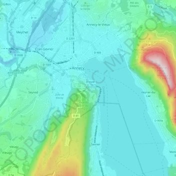
Nom : Carte topographique Annecy, altitude, relief.
Altitude moyenne : 554 m
Altitude minimum : 409 m
Altitude maximum : 1 275 m
Faire un don
Équipez-vous pour votre prochaine aventure :
En tant que Partenaire Amazon, ce site perçoit une commission sur les achats éligibles sans surcoût pour vous.