
Faire un don
Équipez-vous pour votre prochaine aventure :
En tant que Partenaire Amazon, ce site perçoit une commission sur les achats éligibles sans surcoût pour vous.
Carte topographique Żory
Cliquez sur la carte pour afficher l’altitude.
Faire un don
Équipez-vous pour votre prochaine aventure :
En tant que Partenaire Amazon, ce site perçoit une commission sur les achats éligibles sans surcoût pour vous.
Żory
The meaning of the town's name is not clear and there are two theories about it. The first one derives it from Old Polish, from annealing, burning of forests, which was the first stage of establishing a permanent settlement in a given place. This version is related to the primitive economy of burning, which was an element of deforestation of the area for settlement. The topographic description of Upper Silesia from 1865, in turn, derives it from the Polish name of the crane bird (Polish: żuraw). It notes the following passage: "In den verscheidenen Urkunden wird Sohrau einmal Żoraw, dann Żora und auch Sora genannt. Der Name ist polnischen Ursprungs.", that is, in English, "In various documents notated as Żoraw, later Żora, and even Sora. The name is of Polish origin."
Faire un don
Équipez-vous pour votre prochaine aventure :
En tant que Partenaire Amazon, ce site perçoit une commission sur les achats éligibles sans surcoût pour vous.
À propos de cette carte
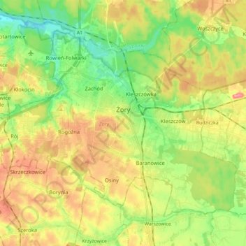
Nom : Carte topographique Żory, altitude, relief.
Lieu : Żory, Silesian Voivodeship, Poland (49.99629 18.60055 50.08160 18.77625)
Altitude moyenne : 263 m
Altitude minimum : 227 m
Altitude maximum : 304 m
Faire un don
Équipez-vous pour votre prochaine aventure :
En tant que Partenaire Amazon, ce site perçoit une commission sur les achats éligibles sans surcoût pour vous.
Autres cartes topographiques
Cliquez sur une carte pour visualiser sa topographie, son altitude et son relief.
Faire un don
Équipez-vous pour votre prochaine aventure :
En tant que Partenaire Amazon, ce site perçoit une commission sur les achats éligibles sans surcoût pour vous.
Zwardoń
Poland > Silesian Voivodeship > Żywiec County
Zwardoń, located at the elevation of 690 meters above sea level, is placed between three mountain passes - Przysłop, Zwardońska and Graniczne. Until 1975, the village was administratively tied with Kraków and Lesser Poland. In 1975 - 1999, it belonged to Bielsko-Biala Voivodeship, and after the territorial…
Altitude moyenne : 710 m
Młyńsko
Poland > Silesian Voivodeship > Żywiec County > Międzybrodzie Bialskie
Altitude moyenne : 454 m
Faire un don
Équipez-vous pour votre prochaine aventure :
En tant que Partenaire Amazon, ce site perçoit une commission sur les achats éligibles sans surcoût pour vous.
Faire un don
Équipez-vous pour votre prochaine aventure :
En tant que Partenaire Amazon, ce site perçoit une commission sur les achats éligibles sans surcoût pour vous.
Faire un don
Équipez-vous pour votre prochaine aventure :
En tant que Partenaire Amazon, ce site perçoit une commission sur les achats éligibles sans surcoût pour vous.
Strzyżowice - Biska
Poland > Silesian Voivodeship > Będzin County > Brzękowice-Wał
Altitude moyenne : 333 m
Faire un don
Équipez-vous pour votre prochaine aventure :
En tant que Partenaire Amazon, ce site perçoit une commission sur les achats éligibles sans surcoût pour vous.
Faire un don
Équipez-vous pour votre prochaine aventure :
En tant que Partenaire Amazon, ce site perçoit une commission sur les achats éligibles sans surcoût pour vous.
Faire un don
Équipez-vous pour votre prochaine aventure :
En tant que Partenaire Amazon, ce site perçoit une commission sur les achats éligibles sans surcoût pour vous.
Wilamowice
Poland > Silesian Voivodeship > Bielsko County > Wilamowice > Wilamowice
Altitude moyenne : 273 m
Faire un don
Équipez-vous pour votre prochaine aventure :
En tant que Partenaire Amazon, ce site perçoit une commission sur les achats éligibles sans surcoût pour vous.
Faire un don
Équipez-vous pour votre prochaine aventure :
En tant que Partenaire Amazon, ce site perçoit une commission sur les achats éligibles sans surcoût pour vous.