
Faire un don
Équipez-vous pour votre prochaine aventure :
En tant que Partenaire Amazon, ce site perçoit une commission sur les achats éligibles sans surcoût pour vous.
Carte topographique Delhi
Cliquez sur la carte pour afficher l’altitude.
Faire un don
Équipez-vous pour votre prochaine aventure :
En tant que Partenaire Amazon, ce site perçoit une commission sur les achats éligibles sans surcoût pour vous.
Delhi
L'arête de Delhi est un petit massif qui trouve son origine dans la chaîne des Aravalli et qui entoure les parties ouest, nord-est et nord-ouest de la ville. Elle atteint l'altitude de 318 m.
Faire un don
Équipez-vous pour votre prochaine aventure :
En tant que Partenaire Amazon, ce site perçoit une commission sur les achats éligibles sans surcoût pour vous.
À propos de cette carte
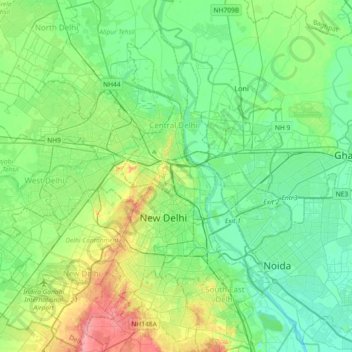
Nom : Carte topographique Delhi, altitude, relief.
Lieu : Delhi, Kotwali Tehsil, Central Delhi, Delhi, 110006, Inde (28.49172 77.06194 28.81172 77.38194)
Altitude moyenne : 216 m
Altitude minimum : 192 m
Altitude maximum : 283 m
Faire un don
Équipez-vous pour votre prochaine aventure :
En tant que Partenaire Amazon, ce site perçoit une commission sur les achats éligibles sans surcoût pour vous.