Géolocaliser

Carte topographique la Vall de Boí

Carte interactive

Cliquez sur la carte pour afficher l’altitude.

À propos de cette carte

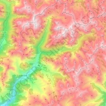
Nom : Carte topographique la Vall de Boí, altitude, relief.

Lieu : la Vall de Boí, Alta Ribagorça, Lleida, Catalonia, Spain (42.45411 0.73941 42.63191 0.97266)

Altitude moyenne : 2 141 m

Altitude minimum : 936 m

Altitude maximum : 2 989 m

The small town of Durro is situated at an elevation of 1,386 metres, on a south-facing mountainside. The church has a single long and narrow nave with a barrel vault and slate roof. It was built with a single apse, now replaced by a sacristy. Two square chapels have been built into the northern wall, and the bell tower rises from the northeast corner to five storeys. The entrance is cut into the southern wall, to a covered walkway. The building has been renovated and extended many times since it was built in the 12th century and little of its original appearance remains. The interior retains Baroque features from later renovations.

Wikipedia (CC-BY-SA 3.0)

Autres cartes topographiques

Cliquez sur une carte pour visualiser sa topographie, son altitude et son relief.

Vilaller

Spain > Catalonia > Alta Ribagorça

Vilaller, Alta Ribagorça, Lleida, Catalonia, 25552, Spain

Altitude moyenne : 1 845 m