
Faire un don
Équipez-vous pour votre prochaine aventure :
En tant que Partenaire Amazon, ce site perçoit une commission sur les achats éligibles sans surcoût pour vous.
Carte topographique Roosevelt
Cliquez sur la carte pour afficher l’altitude.
Faire un don
Équipez-vous pour votre prochaine aventure :
En tant que Partenaire Amazon, ce site perçoit une commission sur les achats éligibles sans surcoût pour vous.
À propos de cette carte
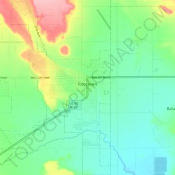
Nom : Carte topographique Roosevelt, altitude, relief.
Altitude moyenne : 1 553 m
Altitude minimum : 1 513 m
Altitude maximum : 1 645 m
Faire un don
Équipez-vous pour votre prochaine aventure :
En tant que Partenaire Amazon, ce site perçoit une commission sur les achats éligibles sans surcoût pour vous.
Autres cartes topographiques
Cliquez sur une carte pour visualiser sa topographie, son altitude et son relief.
Kings Peak
États-Unis d'Amérique > Utah > Duchesne County
Avec 4 123 mètres d'altitude, c'est le point culminant de l'État. Il est nommé d'après le géologue et alpiniste Clarence King.
Altitude moyenne : 3 743 m