
Faire un don
Équipez-vous pour votre prochaine aventure :
En tant que Partenaire Amazon, ce site perçoit une commission sur les achats éligibles sans surcoût pour vous.
Carte topographique Mont Agel
Cliquez sur la carte pour afficher l’altitude.
Faire un don
Équipez-vous pour votre prochaine aventure :
En tant que Partenaire Amazon, ce site perçoit une commission sur les achats éligibles sans surcoût pour vous.
Mont Agel
Le mont Agel est un sommet des Alpes situé dans le Sud de la France. Il domine une partie de la Riviera française, Monaco et les communes françaises de Beausoleil, Roquebrune-Cap-Martin et Gorbio de ses 1 151 mètres d'altitude. Il tient une position stratégique historique depuis l'Antiquité et abrite encore aujourd'hui des installations militaires de détection aérienne.
Faire un don
Équipez-vous pour votre prochaine aventure :
En tant que Partenaire Amazon, ce site perçoit une commission sur les achats éligibles sans surcoût pour vous.
À propos de cette carte
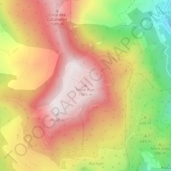
Nom : Carte topographique Mont Agel, altitude, relief.
Altitude moyenne : 790 m
Altitude minimum : 313 m
Altitude maximum : 1 135 m
Faire un don
Équipez-vous pour votre prochaine aventure :
En tant que Partenaire Amazon, ce site perçoit une commission sur les achats éligibles sans surcoût pour vous.