
Faire un don
Équipez-vous pour votre prochaine aventure :
En tant que Partenaire Amazon, ce site perçoit une commission sur les achats éligibles sans surcoût pour vous.
Carte topographique Winter Park
Cliquez sur la carte pour afficher l’altitude.
Faire un don
Équipez-vous pour votre prochaine aventure :
En tant que Partenaire Amazon, ce site perçoit une commission sur les achats éligibles sans surcoût pour vous.
Winter Park
La municipalité s'étend sur 16,50 milles carrés (42,73 km2). Bien que le centre ville se situe à une altitude de 2 750 m, Winter Park est la ville possédant une partie la plus élevée de toutes les États-Unis avec une altitude maximale de 3 700 mètres (ce record est disputé avec Alma par le fait qu'il n'y ait aucun habitant au-dessus de 3 050 mètres).
Faire un don
Équipez-vous pour votre prochaine aventure :
En tant que Partenaire Amazon, ce site perçoit une commission sur les achats éligibles sans surcoût pour vous.
À propos de cette carte
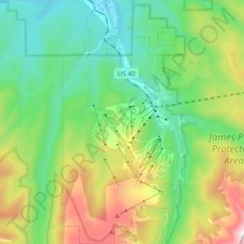
Nom : Carte topographique Winter Park, altitude, relief.
Altitude moyenne : 3 061 m
Altitude minimum : 2 653 m
Altitude maximum : 3 780 m
Faire un don
Équipez-vous pour votre prochaine aventure :
En tant que Partenaire Amazon, ce site perçoit une commission sur les achats éligibles sans surcoût pour vous.