
Faire un don
Équipez-vous pour votre prochaine aventure :
En tant que Partenaire Amazon, ce site perçoit une commission sur les achats éligibles sans surcoût pour vous.
Carte topographique Laramie
Cliquez sur la carte pour afficher l’altitude.
Faire un don
Équipez-vous pour votre prochaine aventure :
En tant que Partenaire Amazon, ce site perçoit une commission sur les achats éligibles sans surcoût pour vous.
Laramie
Laramie est située dans les hautes plaines entre les deux chaînes de montagnes : les monts Medicine Bow à 48 km à l'ouest, et les monts Laramie à 11 km à l'est. La ville est à une altitude de 2 184 m.
Faire un don
Équipez-vous pour votre prochaine aventure :
En tant que Partenaire Amazon, ce site perçoit une commission sur les achats éligibles sans surcoût pour vous.
À propos de cette carte
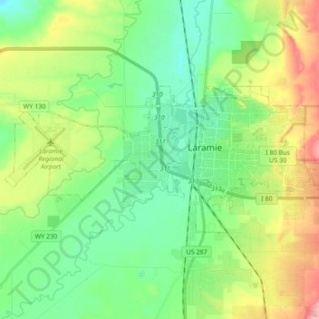
Nom : Carte topographique Laramie, altitude, relief.
Lieu : Laramie, Albany County, Wyoming, États-Unis d'Amérique (41.27742 -105.69729 41.33581 -105.52819)
Altitude moyenne : 2 219 m
Altitude minimum : 2 166 m
Altitude maximum : 2 462 m
Faire un don
Équipez-vous pour votre prochaine aventure :
En tant que Partenaire Amazon, ce site perçoit une commission sur les achats éligibles sans surcoût pour vous.
Autres cartes topographiques
Cliquez sur une carte pour visualiser sa topographie, son altitude et son relief.
Laramie
États-Unis d'Amérique > Wyoming > Albany County
Laramie est située dans les hautes plaines entre les deux chaînes de montagnes : les monts Medicine Bow à 48 km à l'ouest, et les monts Laramie à 11 km à l'est. La ville est à une altitude de 2 184 m.
Altitude moyenne : 2 219 m
Faire un don
Équipez-vous pour votre prochaine aventure :
En tant que Partenaire Amazon, ce site perçoit une commission sur les achats éligibles sans surcoût pour vous.