
Faire un don
Équipez-vous pour votre prochaine aventure :
En tant que Partenaire Amazon, ce site perçoit une commission sur les achats éligibles sans surcoût pour vous.
Carte topographique Lac de Gaube
Cliquez sur la carte pour afficher l’altitude.
Faire un don
Équipez-vous pour votre prochaine aventure :
En tant que Partenaire Amazon, ce site perçoit une commission sur les achats éligibles sans surcoût pour vous.
Lac de Gaube
Le lac se situe à une altitude de 1 725 mètres, il est d'une forme ovoïde s'étirant selon un axe nord-sud comme la vallée de Gaube dans laquelle il se trouve. C'est une petite vallée encaissée démarrant au pied du Vignemale (3 298 m) et finissant au pont d'Espagne. Le lac se trouve dans son dernier tiers (six km au nord du Vignemale et deux km au sud du pont d'Espagne). Le lac est surplombé directement par le pic Mayouret (2 688 m) à l'est, le grand Pic des Paloumères (2 720 m) au sud-est, et le pic de Gaube (2 377 m) au nord-ouest.
Faire un don
Équipez-vous pour votre prochaine aventure :
En tant que Partenaire Amazon, ce site perçoit une commission sur les achats éligibles sans surcoût pour vous.
À propos de cette carte
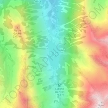
Nom : Carte topographique Lac de Gaube, altitude, relief.
Altitude moyenne : 2 079 m
Altitude minimum : 1 642 m
Altitude maximum : 2 689 m
Faire un don
Équipez-vous pour votre prochaine aventure :
En tant que Partenaire Amazon, ce site perçoit une commission sur les achats éligibles sans surcoût pour vous.
Autres cartes topographiques
Cliquez sur une carte pour visualiser sa topographie, son altitude et son relief.
Vue sur Cascades et Pont d'Espagne
France > Occitanie > Hautes-Pyrénées > Cauterets
Altitude moyenne : 1 827 m
Faire un don
Équipez-vous pour votre prochaine aventure :
En tant que Partenaire Amazon, ce site perçoit une commission sur les achats éligibles sans surcoût pour vous.
Faire un don
Équipez-vous pour votre prochaine aventure :
En tant que Partenaire Amazon, ce site perçoit une commission sur les achats éligibles sans surcoût pour vous.
Faire un don
Équipez-vous pour votre prochaine aventure :
En tant que Partenaire Amazon, ce site perçoit une commission sur les achats éligibles sans surcoût pour vous.
Hourquette d'Ossoue
France > Occitanie > Hautes-Pyrénées > Cauterets
La hourquette d'Ossoue est un col de montagne pédestre des Pyrénées à 2 734 mètres d'altitude, dans le Lavedan, dans le département français des Hautes-Pyrénées en Occitanie.
Altitude moyenne : 2 599 m