
Faire un don
Équipez-vous pour votre prochaine aventure :
En tant que Partenaire Amazon, ce site perçoit une commission sur les achats éligibles sans surcoût pour vous.
Carte topographique Jammu-et-Cachemire
Cliquez sur la carte pour afficher l’altitude.
Faire un don
Équipez-vous pour votre prochaine aventure :
En tant que Partenaire Amazon, ce site perçoit une commission sur les achats éligibles sans surcoût pour vous.
Jammu-et-Cachemire
Le Jammu-et-Cachemire abrite plusieurs vallées telles que la vallée du Cachemire, la vallée du Tawi, la vallée du Chenab, la vallée du Poonch, la vallée du Sind et la vallée du Lidder. L'Himalaya sépare la vallée du Cachemire du plateau tibétain tandis que la chaîne Pir Panjal, qui entoure la vallée à l'ouest et au sud, la sépare des grandes plaines du nord de l'Inde. Le long du flanc nord-est de la vallée s'étend la chaîne principale de l'Himalaya. Cette vallée a une altitude moyenne de 1 850 m, mais la chaîne environnante de Pir Panjal a une altitude moyenne de 3 048 m. La rivière Jhelum est la principale rivière himalayenne qui traverse la vallée du Cachemire. Le Tawi, Ravi et Chenab sont les principaux fleuves qui traversent la région.
Faire un don
Équipez-vous pour votre prochaine aventure :
En tant que Partenaire Amazon, ce site perçoit une commission sur les achats éligibles sans surcoût pour vous.
À propos de cette carte
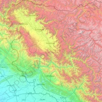
Nom : Carte topographique Jammu-et-Cachemire, altitude, relief.
Lieu : Jammu-et-Cachemire, Inde (32.27636 73.75003 34.78714 76.78032)
Altitude moyenne : 2 430 m
Altitude minimum : 208 m
Altitude maximum : 7 015 m
Faire un don
Équipez-vous pour votre prochaine aventure :
En tant que Partenaire Amazon, ce site perçoit une commission sur les achats éligibles sans surcoût pour vous.
Autres cartes topographiques
Cliquez sur une carte pour visualiser sa topographie, son altitude et son relief.
Faire un don
Équipez-vous pour votre prochaine aventure :
En tant que Partenaire Amazon, ce site perçoit une commission sur les achats éligibles sans surcoût pour vous.
Dharamsala
Inde > Himachal Pradesh > Dharamshala
La ville s'étend sur 27,6 km2 à une altitude moyenne de 1 457 mètres. L'agglomération se divise en deux parties.
Altitude moyenne : 1 781 m
Faire un don
Équipez-vous pour votre prochaine aventure :
En tant que Partenaire Amazon, ce site perçoit une commission sur les achats éligibles sans surcoût pour vous.
Faire un don
Équipez-vous pour votre prochaine aventure :
En tant que Partenaire Amazon, ce site perçoit une commission sur les achats éligibles sans surcoût pour vous.
Udhagamandalam
Inde > Tamil Nadu > Udhagamandalam
Cette station climatique à 2 250 m d'altitude fut fondée au début du XIX siècle pour accueillir le gouvernement de Madras qui voulait prendre le frais en été. Auparavant, cette région était uniquement habitée par les Todas, peuple tribal vouant une adoration toute particulière aux buffles. La ville…
Altitude moyenne : 2 234 m
Faire un don
Équipez-vous pour votre prochaine aventure :
En tant que Partenaire Amazon, ce site perçoit une commission sur les achats éligibles sans surcoût pour vous.
Faire un don
Équipez-vous pour votre prochaine aventure :
En tant que Partenaire Amazon, ce site perçoit une commission sur les achats éligibles sans surcoût pour vous.
Mumbai
Bombay est située dans l'ouest de l'Inde, à l'embouchure du fleuve Ulhas, sur la côte occidentale du pays, appelée à cette latitude côte de Konkan. La ville, qui borde la mer d'Arabie, s'est développée sur l'île de Salsette, dont la partie nord appartient au district de Thane. L'altitude de la ville…
Altitude moyenne : 13 m
Faire un don
Équipez-vous pour votre prochaine aventure :
En tant que Partenaire Amazon, ce site perçoit une commission sur les achats éligibles sans surcoût pour vous.
Faire un don
Équipez-vous pour votre prochaine aventure :
En tant que Partenaire Amazon, ce site perçoit une commission sur les achats éligibles sans surcoût pour vous.
Faire un don
Équipez-vous pour votre prochaine aventure :
En tant que Partenaire Amazon, ce site perçoit une commission sur les achats éligibles sans surcoût pour vous.
Faire un don
Équipez-vous pour votre prochaine aventure :
En tant que Partenaire Amazon, ce site perçoit une commission sur les achats éligibles sans surcoût pour vous.
Munnar
Mūnnār (മുന്നാർ en malayalam, prononcé [ˈmuːnːɑːr]) est une ville du sud-ouest de l'État du Kerala, en Inde, située à environ 1600 m d'altitude sur la chaîne des Ghats occidentaux. Le nom Munnar voudrait dire « trois rivières », la ville étant située au confluent du Muthirappuzha…
Altitude moyenne : 1 603 m
Faire un don
Équipez-vous pour votre prochaine aventure :
En tant que Partenaire Amazon, ce site perçoit une commission sur les achats éligibles sans surcoût pour vous.
Faire un don
Équipez-vous pour votre prochaine aventure :
En tant que Partenaire Amazon, ce site perçoit une commission sur les achats éligibles sans surcoût pour vous.
Kaza
Inde > Himachal Pradesh > Spiti
La ville de Kaza, Kaze ou Kaja est une subdivision de la vallée de Spiti dans le district de Lahaul et Spiti dans l’État de l'Himachal Pradesh, dans l'Ouest de l'Himalaya en Inde. Spiti, qui est une partie du district de Lahaul et Spiti dans l'Himachal, est une région froide de haute altitude ayant…
Altitude moyenne : 4 161 m
Faire un don
Équipez-vous pour votre prochaine aventure :
En tant que Partenaire Amazon, ce site perçoit une commission sur les achats éligibles sans surcoût pour vous.
Faire un don
Équipez-vous pour votre prochaine aventure :
En tant que Partenaire Amazon, ce site perçoit une commission sur les achats éligibles sans surcoût pour vous.
Faire un don
Équipez-vous pour votre prochaine aventure :
En tant que Partenaire Amazon, ce site perçoit une commission sur les achats éligibles sans surcoût pour vous.
Faire un don
Équipez-vous pour votre prochaine aventure :
En tant que Partenaire Amazon, ce site perçoit une commission sur les achats éligibles sans surcoût pour vous.
Faire un don
Équipez-vous pour votre prochaine aventure :
En tant que Partenaire Amazon, ce site perçoit une commission sur les achats éligibles sans surcoût pour vous.
Faire un don
Équipez-vous pour votre prochaine aventure :
En tant que Partenaire Amazon, ce site perçoit une commission sur les achats éligibles sans surcoût pour vous.
Faire un don
Équipez-vous pour votre prochaine aventure :
En tant que Partenaire Amazon, ce site perçoit une commission sur les achats éligibles sans surcoût pour vous.
Faire un don
Équipez-vous pour votre prochaine aventure :
En tant que Partenaire Amazon, ce site perçoit une commission sur les achats éligibles sans surcoût pour vous.
Faire un don
Équipez-vous pour votre prochaine aventure :
En tant que Partenaire Amazon, ce site perçoit une commission sur les achats éligibles sans surcoût pour vous.
Dharamsala
Inde > Himachal Pradesh > Dharamshala
La ville s'étend sur 27,6 km2 à une altitude moyenne de 1 457 mètres. L'agglomération se divise en deux parties.
Altitude moyenne : 1 781 m
Faire un don
Équipez-vous pour votre prochaine aventure :
En tant que Partenaire Amazon, ce site perçoit une commission sur les achats éligibles sans surcoût pour vous.
Mawsynram
Mawsynram est un tehsil de l'État du Meghalaya, situé à l'extrémité ouest du district des East Khasi Hills en Inde et à 56 kilomètres de Shillong, la capitale de l'Etat. Il est réputé pour recevoir le plus de précipitations au monde, car les monts Khasi font barrière à la mousson venant du golfe du…
Altitude moyenne : 1 028 m
Faire un don
Équipez-vous pour votre prochaine aventure :
En tant que Partenaire Amazon, ce site perçoit une commission sur les achats éligibles sans surcoût pour vous.
Delhi
Inde > Delhi > Kotwali Tehsil
L'arête de Delhi est un petit massif qui trouve son origine dans la chaîne des Aravalli et qui entoure les parties ouest, nord-est et nord-ouest de la ville. Elle atteint l'altitude de 318 m.
Altitude moyenne : 216 m
Faire un don
Équipez-vous pour votre prochaine aventure :
En tant que Partenaire Amazon, ce site perçoit une commission sur les achats éligibles sans surcoût pour vous.
Faire un don
Équipez-vous pour votre prochaine aventure :
En tant que Partenaire Amazon, ce site perçoit une commission sur les achats éligibles sans surcoût pour vous.
Faire un don
Équipez-vous pour votre prochaine aventure :
En tant que Partenaire Amazon, ce site perçoit une commission sur les achats éligibles sans surcoût pour vous.