
Faire un don
Équipez-vous pour votre prochaine aventure :
En tant que Partenaire Amazon, ce site perçoit une commission sur les achats éligibles sans surcoût pour vous.
Carte topographique Quilotoa
Cliquez sur la carte pour afficher l’altitude.
Faire un don
Équipez-vous pour votre prochaine aventure :
En tant que Partenaire Amazon, ce site perçoit une commission sur les achats éligibles sans surcoût pour vous.
Quilotoa
Comme le Cotacachi, le volcan Quilotoa possède un lac accessible par un chemin de randonnée (altitude 3 800 m).
Faire un don
Équipez-vous pour votre prochaine aventure :
En tant que Partenaire Amazon, ce site perçoit une commission sur les achats éligibles sans surcoût pour vous.
À propos de cette carte
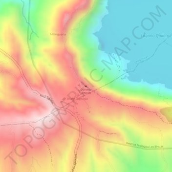
Nom : Carte topographique Quilotoa, altitude, relief.
Lieu : Quilotoa, Chugchillan, Sigchos, Cotopaxi, 050456, Équateur (-0.84920 -78.89713 -0.84910 -78.89703)
Altitude moyenne : 3 553 m
Altitude minimum : 3 326 m
Altitude maximum : 3 827 m
Faire un don
Équipez-vous pour votre prochaine aventure :
En tant que Partenaire Amazon, ce site perçoit une commission sur les achats éligibles sans surcoût pour vous.