
Faire un don
Équipez-vous pour votre prochaine aventure :
En tant que Partenaire Amazon, ce site perçoit une commission sur les achats éligibles sans surcoût pour vous.
Carte topographique Pyrénées
Cliquez sur la carte pour afficher l’altitude.
Faire un don
Équipez-vous pour votre prochaine aventure :
En tant que Partenaire Amazon, ce site perçoit une commission sur les achats éligibles sans surcoût pour vous.
Pyrénées
Les Pyrénées sont une chaîne montagneuse du sud-ouest de l'Europe. Elles s'étendent en longueur selon une direction est-ouest sur une distance approximative de 430 kilomètres depuis la mer Méditerranée (Cap de Creus) jusqu'au golfe de Gascogne (Cap Higuer). Culminant à 3 404 mètres d'altitude au pic d'Aneto, les Pyrénées forment une barrière géographique séparant la péninsule Ibérique au sud du reste de l'Europe continentale au nord. Elles constituent une frontière naturelle entre l'Espagne et la France et abritent aussi la principauté d’Andorre.
Faire un don
Équipez-vous pour votre prochaine aventure :
En tant que Partenaire Amazon, ce site perçoit une commission sur les achats éligibles sans surcoût pour vous.
À propos de cette carte
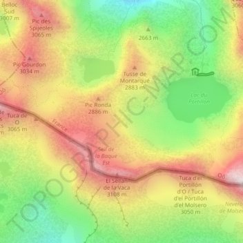
Nom : Carte topographique Pyrénées, altitude, relief.
Altitude moyenne : 2 716 m
Altitude minimum : 2 265 m
Altitude maximum : 3 168 m
Faire un don
Équipez-vous pour votre prochaine aventure :
En tant que Partenaire Amazon, ce site perçoit une commission sur les achats éligibles sans surcoût pour vous.