Faire un don
Équipez-vous pour votre prochaine aventure :
En tant que Partenaire Amazon, ce site perçoit une commission sur les achats éligibles sans surcoût pour vous.
Carte topographique Melbourne
Cliquez sur la carte pour afficher l’altitude.
Faire un don
Équipez-vous pour votre prochaine aventure :
En tant que Partenaire Amazon, ce site perçoit une commission sur les achats éligibles sans surcoût pour vous.
Melbourne
Melbourne is also prone to isolated convective showers forming when a cold pool crosses the state, especially if there is considerable daytime heating. These showers are often heavy and can include hail, squalls, and significant drops in temperature, but they often pass through very quickly with a rapid clearing trend to sunny and relatively calm weather and the temperature rising back to what it was before the shower. This can occur in the space of minutes and can be repeated many times a day, giving Melbourne a reputation for having "four seasons in one day", a phrase that is part of local popular culture. The lowest temperature on record is −2.8 °C (27.0 °F), on 21 July 1869. The highest temperature recorded in Melbourne city was 46.4 °C (115.5 °F), on 7 February 2009. While snow is occasionally seen at higher elevations in the outskirts of the city, it has not been recorded in the Central Business District since 1986.
Faire un don
Équipez-vous pour votre prochaine aventure :
En tant que Partenaire Amazon, ce site perçoit une commission sur les achats éligibles sans surcoût pour vous.
À propos de cette carte
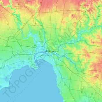
Nom : Carte topographique Melbourne, altitude, relief.
Lieu : Melbourne, City of Melbourne, Victoria, Australia (-37.97425 144.80317 -37.65425 145.12317)
Altitude moyenne : 49 m
Altitude minimum : -5 m
Altitude maximum : 191 m
Faire un don
Équipez-vous pour votre prochaine aventure :
En tant que Partenaire Amazon, ce site perçoit une commission sur les achats éligibles sans surcoût pour vous.
Autres cartes topographiques
Cliquez sur une carte pour visualiser sa topographie, son altitude et son relief.
City of Melbourne
Melbourne's topography is characterized by a diverse landscape that transitions from flat coastal plains to rolling hills and mountainous regions. The city is situated at the northern end of Port Phillip Bay, where the terrain is predominantly flat, facilitating urban development. As one moves eastward, the…
Altitude moyenne : 18 m
Melbourne
Melbourne is also prone to isolated convective showers forming when a cold pool crosses the state, especially if there is considerable daytime heating. These showers are often heavy and can include hail, squalls, and significant drops in temperature, but they often pass through very quickly with a rapid…
Altitude moyenne : 185 m
Mount Buller
Due to its far south-western location in the alpine region, Mount Buller is more susceptible to cold airmasses which allow it to record some of the lowest maximum temperatures and daytime readings in the country, despite being considerably lower in elevation than other mountain sites to the north-east. On 5…
Altitude moyenne : 824 m
Faire un don
Équipez-vous pour votre prochaine aventure :
En tant que Partenaire Amazon, ce site perçoit une commission sur les achats éligibles sans surcoût pour vous.
Grampians National Park
Mount William is known within the gliding community for the "Grampians Wave", a weather phenomenon that sometimes enables glider pilots to reach extreme altitudes of the order of 28,000 ft (8,500 m). This predominantly occurs during the months of May, June, September and October when strong westerly winds flow…
Altitude moyenne : 262 m
Faire un don
Équipez-vous pour votre prochaine aventure :
En tant que Partenaire Amazon, ce site perçoit une commission sur les achats éligibles sans surcoût pour vous.
Faire un don
Équipez-vous pour votre prochaine aventure :
En tant que Partenaire Amazon, ce site perçoit une commission sur les achats éligibles sans surcoût pour vous.
Templestowe
Australia > Victoria > Melbourne
Gentle, rolling hills extend from east of the Yarra River flood plains, along Templestowe Road (towards the Eastern Freeway) for seven km (4.3 miles), to the north-east. The altitude of the plain above sea level is 50 m, and the topography is subdued and mostly flat; the hills are just below 60 m, the slopes…
Altitude moyenne : 66 m
Faire un don
Équipez-vous pour votre prochaine aventure :
En tant que Partenaire Amazon, ce site perçoit une commission sur les achats éligibles sans surcoût pour vous.
Faire un don
Équipez-vous pour votre prochaine aventure :
En tant que Partenaire Amazon, ce site perçoit une commission sur les achats éligibles sans surcoût pour vous.
Faire un don
Équipez-vous pour votre prochaine aventure :
En tant que Partenaire Amazon, ce site perçoit une commission sur les achats éligibles sans surcoût pour vous.
Faire un don
Équipez-vous pour votre prochaine aventure :
En tant que Partenaire Amazon, ce site perçoit une commission sur les achats éligibles sans surcoût pour vous.
Fitzroy
Australia > Victoria > Melbourne
Fitzroy's topography is flat. It is laid out in grid plan and is characterised by a fairly tightly spaced rectangular grid of medium-sized streets, with many of its narrow streets and back lanes facilitating only one-way traffic. Its built form is a legacy of its early history when a mixture of land uses was…
Altitude moyenne : 35 m
Faire un don
Équipez-vous pour votre prochaine aventure :
En tant que Partenaire Amazon, ce site perçoit une commission sur les achats éligibles sans surcoût pour vous.
Faire un don
Équipez-vous pour votre prochaine aventure :
En tant que Partenaire Amazon, ce site perçoit une commission sur les achats éligibles sans surcoût pour vous.
Faire un don
Équipez-vous pour votre prochaine aventure :
En tant que Partenaire Amazon, ce site perçoit une commission sur les achats éligibles sans surcoût pour vous.
Faire un don
Équipez-vous pour votre prochaine aventure :
En tant que Partenaire Amazon, ce site perçoit une commission sur les achats éligibles sans surcoût pour vous.
Faire un don
Équipez-vous pour votre prochaine aventure :
En tant que Partenaire Amazon, ce site perçoit une commission sur les achats éligibles sans surcoût pour vous.
Faire un don
Équipez-vous pour votre prochaine aventure :
En tant que Partenaire Amazon, ce site perçoit une commission sur les achats éligibles sans surcoût pour vous.
Faire un don
Équipez-vous pour votre prochaine aventure :
En tant que Partenaire Amazon, ce site perçoit une commission sur les achats éligibles sans surcoût pour vous.
Western Port
Formerly a major river drainage system, it was inundated together with Port Phillip by the rising sea in the Holocene period; the Western Port sunkland now forms an extensive tidal bay. The waters of Western Port cover an area of 680 km² of which 270 km² are exposed as mud flats at low tide. The topography…
Altitude moyenne : 35 m
Mount Macedon
Due to its relatively high elevation of approximately 620 metres (2,030 ft) AHD, the area experiences much cooler temperatures on average relative to nearby Melbourne. The area also receives high rainfall relative to the surrounding plains and much of the Melbourne area. This combination of geographic factors…
Altitude moyenne : 673 m
Faire un don
Équipez-vous pour votre prochaine aventure :
En tant que Partenaire Amazon, ce site perçoit une commission sur les achats éligibles sans surcoût pour vous.
Faire un don
Équipez-vous pour votre prochaine aventure :
En tant que Partenaire Amazon, ce site perçoit une commission sur les achats éligibles sans surcoût pour vous.
Faire un don
Équipez-vous pour votre prochaine aventure :
En tant que Partenaire Amazon, ce site perçoit une commission sur les achats éligibles sans surcoût pour vous.
Collingwood
Collingwood's topography is mostly flat, but a prominent slope extends from Hoddle Street up to Smith Street, and also along sections of Hoddle Street.
Altitude moyenne : 30 m
Faire un don
Équipez-vous pour votre prochaine aventure :
En tant que Partenaire Amazon, ce site perçoit une commission sur les achats éligibles sans surcoût pour vous.
Faire un don
Équipez-vous pour votre prochaine aventure :
En tant que Partenaire Amazon, ce site perçoit une commission sur les achats éligibles sans surcoût pour vous.
Camberwell
Australia > Victoria > Melbourne
The Prospect Hill Road Precinct area is adjacent to the railway station and is the oldest part of the suburb. The original subdivision was relatively generous blocks, which were quickly filled with fine Victorian and Edwardian houses. Due to its hilly topography, many east–west streets in the Prospect Hill…
Altitude moyenne : 66 m
Faire un don
Équipez-vous pour votre prochaine aventure :
En tant que Partenaire Amazon, ce site perçoit une commission sur les achats éligibles sans surcoût pour vous.
Bairnsdale
A comprehensive geological survey of Victoria's Great Dividing Range reveals a distinct north-south alignment in its bedrock, a vestige of the bygone epochs of plate tectonics. This enduring geological framework, coupled with ongoing tectonic activity, contributes to the dynamic topography witnessed in the…
Altitude moyenne : 25 m
Faire un don
Équipez-vous pour votre prochaine aventure :
En tant que Partenaire Amazon, ce site perçoit une commission sur les achats éligibles sans surcoût pour vous.
Faire un don
Équipez-vous pour votre prochaine aventure :
En tant que Partenaire Amazon, ce site perçoit une commission sur les achats éligibles sans surcoût pour vous.
Faire un don
Équipez-vous pour votre prochaine aventure :
En tant que Partenaire Amazon, ce site perçoit une commission sur les achats éligibles sans surcoût pour vous.
Langwarrin Flora and Fauna Reserve
Australia > Victoria > Melbourne > Langwarrin
Altitude moyenne : 90 m
Faire un don
Équipez-vous pour votre prochaine aventure :
En tant que Partenaire Amazon, ce site perçoit une commission sur les achats éligibles sans surcoût pour vous.
Faire un don
Équipez-vous pour votre prochaine aventure :
En tant que Partenaire Amazon, ce site perçoit une commission sur les achats éligibles sans surcoût pour vous.
