
Faire un don
Équipez-vous pour votre prochaine aventure :
En tant que Partenaire Amazon, ce site perçoit une commission sur les achats éligibles sans surcoût pour vous.
Carte topographique Wichita
Cliquez sur la carte pour afficher l’altitude.
Faire un don
Équipez-vous pour votre prochaine aventure :
En tant que Partenaire Amazon, ce site perçoit une commission sur les achats éligibles sans surcoût pour vous.
Wichita
Wichita se trouve dans le Centre des États-Unis, sur la rive orientale de la rivière Arkansas, à la confluence avec la Little Arkansas River, et près de la limite ouest des collines de Flint dans la région des basses terres Wellington-McPherson des Grandes Plaines. La topographie de la région est caractérisée par la vaste plaine alluviale de la vallée de la rivière Arkansas et les pentes modérément vallonnées qui s’élèvent de chaque côté vers les terres plus élevées.
Faire un don
Équipez-vous pour votre prochaine aventure :
En tant que Partenaire Amazon, ce site perçoit une commission sur les achats éligibles sans surcoût pour vous.
À propos de cette carte
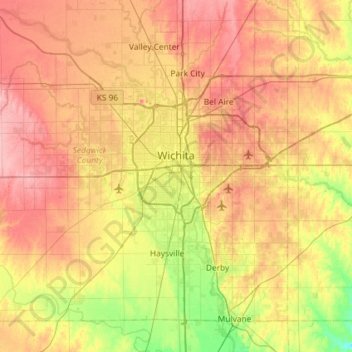
Nom : Carte topographique Wichita, altitude, relief.
Lieu : Wichita, Sedgwick County, Kansas, États-Unis d'Amérique (37.48902 -97.73435 37.84020 -97.15300)
Altitude moyenne : 408 m
Altitude minimum : 355 m
Altitude maximum : 459 m
Faire un don
Équipez-vous pour votre prochaine aventure :
En tant que Partenaire Amazon, ce site perçoit une commission sur les achats éligibles sans surcoût pour vous.
Autres cartes topographiques
Cliquez sur une carte pour visualiser sa topographie, son altitude et son relief.