
Faire un don
Équipez-vous pour votre prochaine aventure :
En tant que Partenaire Amazon, ce site perçoit une commission sur les achats éligibles sans surcoût pour vous.
Carte topographique Barrage Hoover
Cliquez sur la carte pour afficher l’altitude.
Faire un don
Équipez-vous pour votre prochaine aventure :
En tant que Partenaire Amazon, ce site perçoit une commission sur les achats éligibles sans surcoût pour vous.
À propos de cette carte
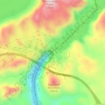
Nom : Carte topographique Barrage Hoover, altitude, relief.
Altitude moyenne : 429 m
Altitude minimum : 197 m
Altitude maximum : 682 m
Faire un don
Équipez-vous pour votre prochaine aventure :
En tant que Partenaire Amazon, ce site perçoit une commission sur les achats éligibles sans surcoût pour vous.
Autres cartes topographiques
Cliquez sur une carte pour visualiser sa topographie, son altitude et son relief.
Kingman
États-Unis d'Amérique > Arizona > Mohave County
Traversée par la célèbre route 66, la ville de Kingman se dit le cœur de cette dernière (The Heart of historic route 66). Située à quelques kilomètres de Bullhead City et à environ deux heures de route du parc national du Grand Canyon, la vie est relativement loin de la ville urbaine de la capitale…
Altitude moyenne : 1 131 m
Faire un don
Équipez-vous pour votre prochaine aventure :
En tant que Partenaire Amazon, ce site perçoit une commission sur les achats éligibles sans surcoût pour vous.
Dolan Springs
États-Unis d'Amérique > Arizona > Mohave County > Dolan Springs
Altitude moyenne : 1 188 m
Kingman
États-Unis d'Amérique > Arizona > Mohave County > Kingman
Traversée par la célèbre route 66, la ville de Kingman se dit le cœur de cette dernière (The Heart of historic route 66). Située à quelques kilomètres de Bullhead City et à environ deux heures de route du parc national du Grand Canyon, la vie est relativement loin de la ville urbaine de la capitale…
Altitude moyenne : 1 116 m
Faire un don
Équipez-vous pour votre prochaine aventure :
En tant que Partenaire Amazon, ce site perçoit une commission sur les achats éligibles sans surcoût pour vous.