
Faire un don
Équipez-vous pour votre prochaine aventure :
En tant que Partenaire Amazon, ce site perçoit une commission sur les achats éligibles sans surcoût pour vous.
Carte topographique Tekkeköy
Cliquez sur la carte pour afficher l’altitude.
Faire un don
Équipez-vous pour votre prochaine aventure :
En tant que Partenaire Amazon, ce site perçoit une commission sur les achats éligibles sans surcoût pour vous.
Tekkeköy
The Hacı Osman grove, which stretches along the coast, Kapaklı Pınar, Kırantepe, Azman, and Asarağaç hills at 700 to 800 m altitudes are popular spots for picnicking and other recreational activities.
Faire un don
Équipez-vous pour votre prochaine aventure :
En tant que Partenaire Amazon, ce site perçoit une commission sur les achats éligibles sans surcoût pour vous.
À propos de cette carte
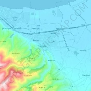
Nom : Carte topographique Tekkeköy, altitude, relief.
Lieu : Tekkeköy, Samsun, Black Sea Region, 55300, Turkey (41.17350 36.41780 41.25350 36.49780)
Altitude moyenne : 114 m
Altitude minimum : 0 m
Altitude maximum : 668 m
Faire un don
Équipez-vous pour votre prochaine aventure :
En tant que Partenaire Amazon, ce site perçoit une commission sur les achats éligibles sans surcoût pour vous.