Géolocaliser

Carte topographique Tre Cime di Lavaredo - Drei Zinnen

Carte interactive

Cliquez sur la carte pour afficher l’altitude.

À propos de cette carte

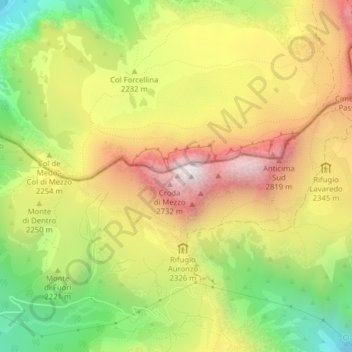
Nom : Carte topographique Tre Cime di Lavaredo - Drei Zinnen, altitude, relief.

Lieu : Tre Cime di Lavaredo - Drei Zinnen, Auronzo di Cadore, Pustertal - Val Pusteria, Belluno, Veneto, 39034, Italy (46.61417 12.28695 46.62127 12.30983)

Altitude moyenne : 2 242 m

Altitude minimum : 1 667 m

Altitude maximum : 2 813 m

Until 1919 the peaks formed part of the border between Italy and Austria-Hungary. Now they lie on the border between the Italian provinces of South Tyrol and Belluno and still are a part of the linguistic boundary between German-speaking and Italian-speaking majorities. The Cima Grande has an elevation of 2,999 metres (9,839 ft). It stands between the Cima Piccola, at 2,857 metres (9,373 ft), and the Cima Ovest, at 2,973 metres (9,754 ft).

Wikipedia (CC-BY-SA 3.0)

Autres cartes topographiques

Cliquez sur une carte pour visualiser sa topographie, son altitude et son relief.

Misurina

Italy > Veneto > Belluno > Auronzo di Cadore

Misurina, Auronzo di Cadore, Belluno, Veneto, Italy

Altitude moyenne : 1 954 m

Monte Piana

Italy > Veneto > Belluno > Auronzo di Cadore

Monte Piana, Auronzo di Cadore, Belluno, Veneto, Italy

Altitude moyenne : 1 850 m

Zwölferkofel - Croda dei Toni

Italy > Veneto > Belluno > Auronzo di Cadore

Zwölferkofel - Croda dei Toni, Auronzo di Cadore, Belluno, Veneto, Italy

Altitude moyenne : 2 367 m