Géolocaliser

Carte topographique Braga

Carte interactive

Cliquez sur la carte pour afficher l’altitude.

À propos de cette carte

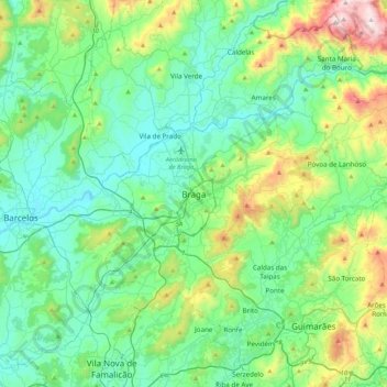
Nom : Carte topographique Braga, altitude, relief.

Lieu : Braga, Maximinos, Sé e Cividade, Braga, 4700-435, Portugal (41.39106 -8.58800 41.71106 -8.26800)

Altitude moyenne : 204 m

Altitude minimum : 4 m

Altitude maximum : 908 m

The topography in the municipality is characterized by irregular valleys, interspersed by mountainous spaces, fed by rivers running in parallel with the principal rivers. In the north it is limited by the Cávado River, in the south by terrain of the Serra dos Picos to a height of 566 metres (1,857 ft) and towards the east by the Serra dos Carvalhos to a height of 479 metres (1,572 ft), opening to the municipalities of Vila Nova de Famalicão and Barcelos. The territory extends from the northeast to southwest, accompanying the valleys of the two rivers, fed by many of its tributaries, forming small platforms between 20 metres (66 ft) and 570 metres (1,870 ft).

Autres cartes topographiques

Cliquez sur une carte pour visualiser sa topographie, son altitude et son relief.

Real

Portugal > Braga > Braga

Real, Braga, 4700-282, Portugal

Altitude moyenne : 117 m

Frossos

Portugal > Braga > Braga

Frossos, Braga, 4710-154, Portugal

Altitude moyenne : 88 m

Santa Lucrécia de Algeriz e Navarra

Portugal > Braga > Braga

Santa Lucrécia de Algeriz e Navarra, Braga, Portugal

Altitude moyenne : 149 m

Frossos

Portugal > Braga > Braga

Frossos, Merelim (São Pedro) e Frossos, Braga, Portugal

Altitude moyenne : 73 m

Lamas

Portugal > Braga > Braga

Lamas, Braga, 4705-480, Portugal

Altitude moyenne : 189 m