Géolocaliser

Carte topographique Hamburg

Carte interactive

Cliquez sur la carte pour afficher l’altitude.

À propos de cette carte
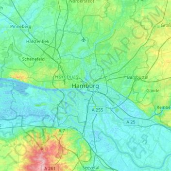
Nom : Carte topographique Hamburg, altitude, relief.

Lieu : Hamburg, 20095, Germany (53.39034 9.84065 53.71034 10.16065)

Altitude moyenne : 23 m

Altitude minimum : -3 m

Altitude maximum : 150 m

The neighborhoods of Neuenfelde, Cranz, Francop and Finkenwerder are part of the Altes Land (old land) region, the largest contiguous fruit-producing region in Central Europe. Neugraben-Fischbek has Hamburg's highest elevation, the Hasselbrack at 116.2 metres (381 ft) AMSL. Hamburg borders the states of Schleswig-Holstein and Lower Saxony.

Autres cartes topographiques

Cliquez sur une carte pour visualiser sa topographie, son altitude et son relief.

Altona-Nord

Germany > Hamburg > Hamburg

Altona-Nord, Altona, Hamburg, 22769, Germany

Altitude moyenne : 24 m

Hammerbrook

Germany > Hamburg > Hamburg

Hammerbrook, Hamburg-Mitte, Hamburg, 20097, Germany

Altitude moyenne : 8 m

Ottensen

Germany > Hamburg > Hamburg

Ottensen, Altona, Hamburg, Germany

Altitude moyenne : 23 m

St. Pauli

Germany > Hamburg > Hamburg

St. Pauli, Hamburg-Mitte, Hamburg, Germany

Altitude moyenne : 19 m