Géolocaliser

Carte topographique Kootenay National Park

Carte interactive

Cliquez sur la carte pour afficher l’altitude.

À propos de cette carte

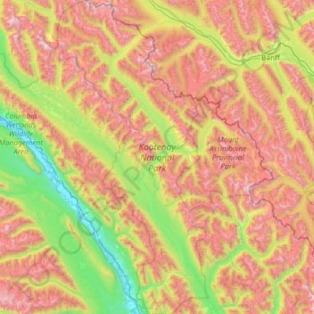
Nom : Carte topographique Kootenay National Park, altitude, relief.

Lieu : Kootenay National Park, Area G (Forster Creek/Mount Assiniboine), Regional District of East Kootenay, British Columbia, Canada (50.57593 -116.36079 51.30785 -115.80217)

Altitude moyenne : 1 832 m

Altitude minimum : 786 m

Altitude maximum : 3 410 m

Kootenay National Park is a national park of Canada located in southeastern British Columbia. The park consists of 1,406 km2 (543 sq mi) of the Canadian Rockies, including parts of the Kootenay and Park mountain ranges, the Kootenay River and the entirety of the Vermilion River. While the Vermilion River is completely contained within the park, the Kootenay River has its headwaters just outside the park boundary, flowing through the park into the Rocky Mountain Trench and eventually joining the Columbia River. The park ranges in elevation from 918 m (3,012 ft) at the southwestern park entrance to 3,424 m (11,234 ft) at Deltaform Mountain.

Wikipedia (CC-BY-SA 3.0)

Autres cartes topographiques

Cliquez sur une carte pour visualiser sa topographie, son altitude et son relief.

The Nublet

Canada > British Columbia > Regional District of East Kootenay > Area G (Forster Creek/Mount Assiniboine)

The Nublet, Area G (Forster Creek/Mount Assiniboine), Regional District of East Kootenay, British Columbia, Canada

Altitude moyenne : 2 301 m

Spillimacheen

Canada > British Columbia > Regional District of East Kootenay > Area G (Forster Creek/Mount Assiniboine)

Spillimacheen, Area G (Forster Creek/Mount Assiniboine), Regional District of East Kootenay, British Columbia, Canada

Altitude moyenne : 971 m

Kootenay National Park

Canada > British Columbia > Regional District of East Kootenay > Area G (Forster Creek/Mount Assiniboine)

Kootenay National Park, Area G (Forster Creek/Mount Assiniboine), Regional District of East Kootenay, British Columbia, Canada

Altitude moyenne : 1 832 m

Cobb Lake

Canada > British Columbia > Regional District of East Kootenay > Area G (Forster Creek/Mount Assiniboine)

Cobb Lake, Area G (Forster Creek/Mount Assiniboine), Regional District of East Kootenay, British Columbia, Canada

Altitude moyenne : 1 366 m

Purcell Mountains

Canada > British Columbia > Regional District of East Kootenay > Area G (Forster Creek/Mount Assiniboine)

Purcell Mountains, Area G (Forster Creek/Mount Assiniboine), Regional District of East Kootenay, British Columbia, Canada

Altitude moyenne : 2 710 m

Baptiste Lake

Canada > British Columbia > Regional District of East Kootenay > Area G (Forster Creek/Mount Assiniboine)

Baptiste Lake, Area G (Forster Creek/Mount Assiniboine), Regional District of East Kootenay, British Columbia, Canada

Altitude moyenne : 1 067 m

Edgewater

Canada > British Columbia > Regional District of East Kootenay > Area G (Forster Creek/Mount Assiniboine) > Edgewater

Edgewater, Area G (Forster Creek/Mount Assiniboine), Regional District of East Kootenay, British Columbia, V0A 1E0, Canada

Altitude moyenne : 874 m

Assiniboine Lodge

Canada > British Columbia > Regional District of East Kootenay > Area G (Forster Creek/Mount Assiniboine)

Assiniboine Lodge, Wonder Pass / Marvel Lake Trail, Area G (Forster Creek/Mount Assiniboine), Regional District of East Kootenay, British Columbia, Canada

Altitude moyenne : 2 208 m

The Bugaboos

Canada > British Columbia > Regional District of East Kootenay > Area G (Forster Creek/Mount Assiniboine)

The Bugaboos, Area G (Forster Creek/Mount Assiniboine), Regional District of East Kootenay, British Columbia, Canada

Altitude moyenne : 2 421 m

Redstreak Mountain

Canada > British Columbia > Regional District of East Kootenay > Area G (Forster Creek/Mount Assiniboine)

Redstreak Mountain, Area G (Forster Creek/Mount Assiniboine), Regional District of East Kootenay, British Columbia, Canada

Altitude moyenne : 1 603 m