Géolocaliser

Carte topographique Adana

Carte interactive

Cliquez sur la carte pour afficher l’altitude.

À propos de cette carte

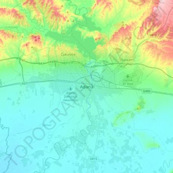
Nom : Carte topographique Adana, altitude, relief.

Lieu : Adana, Seyhan, Adana, Mediterranean Region, 01010, Turkey (36.82636 35.16529 37.14636 35.48529)

Altitude moyenne : 61 m

Altitude minimum : 3 m

Altitude maximum : 312 m

Heading west across Cilicia from Adana, the path to Tarsus crosses the foothills of the Taurus Mountains, eventually reaching an altitude of nearly 1,200 metres (4,000 ft) while passing through the Cilician Gates (Turkish: Gülek Boğazı), a rocky mountain pass functioning as the main artery to the Turkish hinterland.

Wikipedia (CC-BY-SA 3.0)