
Carte topographique Manipur
Carte interactive
Cliquez sur la carte pour afficher l’altitude.
À propos de cette carte
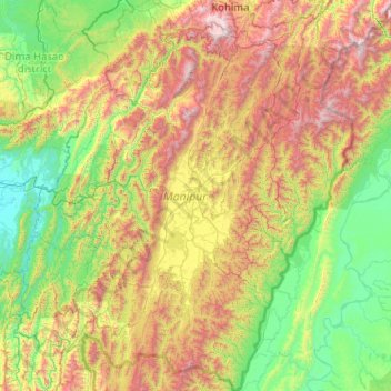
Nom : Carte topographique Manipur, altitude, relief.
Lieu : Manipur, India (23.83362 92.97071 25.69210 94.74524)
Altitude moyenne : 810 m
Altitude minimum : 19 m
Altitude maximum : 2 997 m
The state lies at a latitude of 23°83'N – 25°68'N and a longitude of 93°03'E – 94°78'E. The total area covered by the state is 22,327 square kilometres (8,621 sq mi). The capital lies in an oval-shaped valley of approximately 700 square miles (2,000 km2), surrounded by blue mountains, at an elevation of 790 metres (2,590 ft) above sea level. The slope of the valley is from north to south. The mountain ranges create a moderated climate, preventing the cold winds from the north from reaching the valley and barring cyclonic storms.
Autres cartes topographiques
Cliquez sur une carte pour visualiser sa topographie, son altitude et son relief.
Bengaluru
India > Karnataka > Bangalore North
Bengaluru, Bangalore North, Bengaluru Urban District, Karnataka, India
Altitude moyenne : 881 m
Chennai
India > Tamil Nadu > Chennai
Chennai, Chennai District, Tamil Nadu, India
Altitude moyenne : 8 m
3d
India > Rajasthan > Ganganagar Tehsil > 1 LNP
3d, 1 LNP, Ganganagar Tehsil, Sri Ganganagar District, Rajasthan, India
Altitude moyenne : 178 m
Western Ghats
Western Ghats, Idukki, Kerala, 685614, India
Altitude moyenne : 2 225 m
Bachupally mandal
Bachupally mandal, Medchal–Malkajgiri District, Telangana, 500090, India
Altitude moyenne : 593 m
North Sentinel Island
India > Andaman and Nicobar Islands > Ferrargunj
North Sentinel Island, Ferrargunj, South Andaman District, Andaman and Nicobar Islands, India
Altitude moyenne : 20 m
Maduranthakam
Maduranthakam, Chengalpattu District, Tamil Nadu, India
Altitude moyenne : 37 m
Pune
India > Maharashtra > Pune City > Pune
Pune, Pune City, Pune District, Maharashtra, 411001, India
Altitude moyenne : 641 m
Kodaikanal
Kodaikanal, Dindigul District, Tamil Nadu, India
Altitude moyenne : 869 m
Jaipur
India > Rajasthan > Jaipur Tehsil
Jaipur, Jaipur Municipal Corporation, Jaipur Tehsil, Jaipur District, Rajasthan, 302001, India
Altitude moyenne : 408 m
Kolkata
Kolkata, Kolkata District, West Bengal, 700073, India
Altitude moyenne : 5 m
Tharangambadi
Tharangambadi, Mayiladuthurai District, Tamil Nadu, India
Altitude moyenne : 5 m
Gurgaon
India > Haryana > Gurugram District
Gurgaon, Gurugram District, Haryana, India
Altitude moyenne : 237 m
Mysuru
India > Karnataka > Mysuru taluk
Mysuru, Mysuru taluk, Mysuru District, Karnataka, 570001, India
Altitude moyenne : 727 m
Indore
India > Madhya Pradesh > Juni Indore Tahsil
Indore, Juni Indore Tahsil, Indore District, Madhya Pradesh, 452001, India
Altitude moyenne : 555 m
Kanchanpur
India > Madhya Pradesh > Karkeli Tahsil
Kanchanpur, Karkeli Tahsil, Umaria District, Madhya Pradesh, India
Altitude moyenne : 500 m
Thuneri
India > Tamil Nadu > Udhagamandalam
Thuneri, Udhagamandalam, Nilgiris District, Tamil Nadu, 643402, India
Altitude moyenne : 1 899 m
Hosur
India > Tamil Nadu > Hosur
Hosur, Krishnagiri District, Tamil Nadu, 635109, India
Altitude moyenne : 859 m
Vijayawada
India > Andhra Pradesh > Vijayawada (Urban)
Vijayawada, Vijayawada (Urban), NTR District, Andhra Pradesh, 520001, India
Altitude moyenne : 36 m
Prayagraj
India > Uttar Pradesh > Prayagraj
Prayagraj, Prayagraj District, Uttar Pradesh, 211001, India
Altitude moyenne : 91 m