
Carte topographique Tehri-Garhwal
Carte interactive
Cliquez sur la carte pour afficher l’altitude.
À propos de cette carte
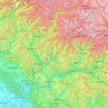
Nom : Carte topographique Tehri-Garhwal, altitude, relief.
Lieu : Tehri-Garhwal, Tehri Garhwal, Uttarakhand, Inde (29.86000 78.02667 31.14000 79.30667)
Altitude moyenne : 2 311 m
Altitude minimum : 251 m
Altitude maximum : 7 106 m
Autres cartes topographiques
Cliquez sur une carte pour visualiser sa topographie, son altitude et son relief.
Pattiyonwāla
Inde > Uttarakhand > Pattiyonwāla
Pattiyonwāla, Dehra Dūn, Dehradun, Uttarakhand, 248171, Inde
Altitude moyenne : 618 m