
Carte topographique Sanjay Gandhi (Borivilli) National Park
Carte interactive
Cliquez sur la carte pour afficher l’altitude.
À propos de cette carte
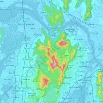
Nom : Carte topographique Sanjay Gandhi (Borivilli) National Park, altitude, relief.
Altitude moyenne : 42 m
Altitude minimum : -4 m
Altitude maximum : 479 m
The region is hilly with elevations between 30 and 480 m (98 and 1,575 ft). The park has two lakes, Vihar Lake and Tulsi Lake, which meet a part of the city's water requirements. The park is said to be the lungs of the city as it purifies much of the air pollution of the city.
Autres cartes topographiques
Cliquez sur une carte pour visualiser sa topographie, son altitude et son relief.
Dahisar River
India > Maharashtra > Thane > Mumbai
Dahisar River, Zone 4, Mumbai, Mumbai Metropolitan Region, Thane, Mumbai Suburban, Maharashtra, 400068, India
Altitude moyenne : 83 m