
Carte topographique Whiteknights Lake
Carte interactive
Cliquez sur la carte pour afficher l’altitude.
À propos de cette carte
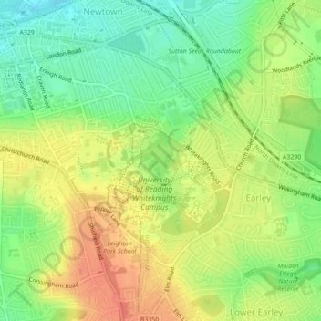
Nom : Carte topographique Whiteknights Lake, altitude, relief.
Altitude moyenne : 61 m
Altitude minimum : 36 m
Altitude maximum : 85 m
Autres cartes topographiques
Cliquez sur une carte pour visualiser sa topographie, son altitude et son relief.
Forest of Arden
United Kingdom > England > Reading
Forest of Arden, Whitley, Reading, England, United Kingdom
Altitude moyenne : 64 m
View Island
United Kingdom > England > Reading
View Island, Reading Hydro, Caversham, Reading, England, United Kingdom
Altitude moyenne : 45 m