
Carte topographique Virginia
Carte interactive
Cliquez sur la carte pour afficher l’altitude.
À propos de cette carte
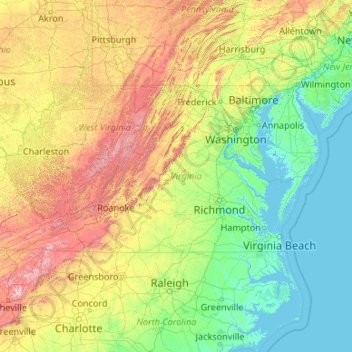
Nom : Carte topographique Virginia, altitude, relief.
Lieu : Virginia, United States (36.54079 -83.67537 39.46601 -75.16644)
Altitude moyenne : 248 m
Altitude minimum : -3 m
Altitude maximum : 1 906 m
Forests cover 62% of Virginia as of 2019, of which 78% is considered hardwood forest, meaning that trees in Virginia are primarily deciduous and broad-leaved. The other 22% is pine, with Loblolly and shortleaf pine dominating much of central and eastern Virginia. In the western and mountainous parts of the Commonwealth, oak and hickory are most common, while lower altitudes are more likely to have small but dense stands of moisture-loving hemlocks and mosses in abundance. Spongy moth infestations in oak trees and the blight in chestnut trees have decreased both of their numbers, leaving more room for hickory and invasive ailanthus trees. In the lowland tidewater and Piedmont, yellow pines tend to dominate, with bald cypress wetland forests in the Great Dismal and Nottoway swamps. Other common trees include red spruce, Atlantic White cedar, tulip-poplar, and the flowering dogwood, the state tree and flower, as well as willows, ashes, and laurels. Plants like milkweed, dandelions, daisies, ferns, and Virginia creeper, which is featured on the state flag, are also common. The Thompson Wildlife Area in Fauquier is known for one of the largest populations of trillium wildflowers in all of North America.
Autres cartes topographiques
Cliquez sur une carte pour visualiser sa topographie, son altitude et son relief.
Houston
United States > Texas > Harris County
Houston, Harris County, Texas, United States
Altitude moyenne : 25 m
Seattle
United States > Washington > King County
Seattle, King County, Washington, United States
Altitude moyenne : 40 m
San Francisco
San Francisco, California, United States
Altitude moyenne : 63 m
Portland
United States > Oregon > Multnomah County
Portland, Multnomah County, Oregon, United States
Altitude moyenne : 77 m
Denver
United States > Colorado > Denver County > Denver
Denver, Denver County, Colorado, United States
Altitude moyenne : 1 684 m
San Diego
United States > California > San Diego County
San Diego, San Diego County, California, United States
Altitude moyenne : 125 m
Phoenix
United States > Arizona > Maricopa County
Phoenix, Maricopa County, Arizona, United States
Altitude moyenne : 481 m
Dallas
United States > Texas > Dallas County
Dallas, Dallas County, Texas, United States
Altitude moyenne : 160 m
Tampa
United States > Florida > Hillsborough County
Tampa, Hillsborough County, Florida, United States
Altitude moyenne : 11 m
Austin
United States > Texas > Travis County
Austin, Travis County, Texas, United States
Altitude moyenne : 216 m
San Antonio
United States > Texas > Bexar County
San Antonio, Bexar County, Texas, United States
Altitude moyenne : 247 m
Pittsburgh
United States > Pennsylvania > Allegheny County
Pittsburgh, Allegheny County, Pennsylvania, United States
Altitude moyenne : 303 m
Atlanta
United States > Georgia > Fulton County
Atlanta, Fulton County, Georgia, United States
Altitude moyenne : 284 m
Charleston
United States > South Carolina > Charleston County
Charleston, Charleston County, South Carolina, United States
Altitude moyenne : 4 m
Boston
United States > Massachusetts > Suffolk County
Boston, Suffolk County, Massachusetts, United States
Altitude moyenne : 25 m
Cincinnati
United States > Ohio > Hamilton County
Cincinnati, Hamilton County, Ohio, United States
Altitude moyenne : 222 m
Salt Lake City
United States > Utah > Salt Lake County
Salt Lake City, Salt Lake County, Utah, United States
Altitude moyenne : 1 592 m
Miami
United States > Florida > Miami-Dade County
Miami, Miami-Dade County, Florida, United States
Altitude moyenne : 5 m
Manhattan
United States > New York > New York County > New York
Manhattan, New York County, New York, United States
Altitude moyenne : 16 m
Philadelphia
United States > Pennsylvania > Philadelphia County
Philadelphia, Pennsylvania, United States
Altitude moyenne : 44 m
Chicago
United States > Illinois > Cook County
Chicago, Cook County, Illinois, United States
Altitude moyenne : 182 m
Reno
United States > Nevada > Washoe County
Reno, Washoe County, Nevada, United States
Altitude moyenne : 1 650 m
Oklahoma City
United States > Oklahoma > Oklahoma County
Oklahoma City, Oklahoma County, Oklahoma, United States
Altitude moyenne : 362 m
Bellingham
United States > Washington > Whatcom County
Bellingham, Whatcom County, Washington, United States
Altitude moyenne : 89 m
Tucson
United States > Arizona > Pima County
Tucson, Pima County, Arizona, United States
Altitude moyenne : 822 m
Albuquerque
United States > New Mexico > Bernalillo County
Albuquerque, Bernalillo County, New Mexico, United States
Altitude moyenne : 1 688 m
Eugene
United States > Oregon > Lane County
Eugene, Lane County, Oregon, United States
Altitude moyenne : 163 m
Tulsa
United States > Oklahoma > Tulsa County
Tulsa, Tulsa County, Oklahoma, United States
Altitude moyenne : 221 m
Ann Arbor
United States > Michigan > Washtenaw County
Ann Arbor, Washtenaw County, Michigan, United States
Altitude moyenne : 268 m
Orlando
United States > Florida > Orange County
Orlando, Orange County, Florida, United States
Altitude moyenne : 30 m
Lincoln
United States > Nebraska > Lancaster County
Lincoln, Lancaster County, Nebraska, United States
Altitude moyenne : 379 m
Colorado Springs
United States > Colorado > El Paso County
Colorado Springs, El Paso County, Colorado, United States
Altitude moyenne : 2 252 m
Nashville-Davidson
United States > Tennessee > Davidson County
Nashville-Davidson, Davidson County, Middle Tennessee, Tennessee, United States
Altitude moyenne : 184 m