
Carte topographique Khangchendzonga National Park
Carte interactive
Cliquez sur la carte pour afficher l’altitude.
À propos de cette carte
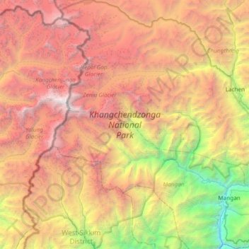
Nom : Carte topographique Khangchendzonga National Park, altitude, relief.
Altitude moyenne : 4 330 m
Altitude minimum : 599 m
Altitude maximum : 8 521 m
The Kanchenjunga Park is situated in the North and West Sikkim districts in the Indian state of Sikkim. It has an elevation of 1,829 metres (6,001 ft) to over 8,550 metres (28,050 ft) and has an area of 849.50 km2 (327.99 sq mi). It is one of the few high-altitude National parks of India and was recently included as a mixed-criteria UNESCO World Heritage site.
Autres cartes topographiques
Cliquez sur une carte pour visualiser sa topographie, son altitude et son relief.
East Sikkim District
India > Sikkim > Pakyong subdivision
East Sikkim District, Pakyong subdivision, Pakyong district, Sikkim, India
Altitude moyenne : 2 107 m
West District
West District, West Sikkim District, Sikkim, 737111, India
Altitude moyenne : 2 636 m
Lachung
India > Sikkim > Chungthang
Lachung, Chungthang, Mangan District, Sikkim, India
Altitude moyenne : 3 617 m
East District
India > Sikkim > East District
East District, East Sikkim District, Sikkim, India
Altitude moyenne : 2 740 m
Zemu Glacier
Zemu Glacier, North District, North Sikkim District, Sikkim, India
Altitude moyenne : 5 499 m
South District
South District, South Sikkim District, Sikkim, India
Altitude moyenne : 2 676 m
North District
North District, North Sikkim District, Sikkim, India
Altitude moyenne : 3 760 m