
Carte topographique Snellville
Carte interactive
Cliquez sur la carte pour afficher l’altitude.
À propos de cette carte
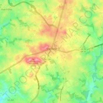
Nom : Carte topographique Snellville, altitude, relief.
Lieu : Snellville, Gwinnett County, Georgia, United States (33.81839 -84.04291 33.89217 -83.95093)
Altitude moyenne : 300 m
Altitude minimum : 247 m
Altitude maximum : 363 m
Compared to most large cities around the world at approximately the same latitude (33°39'), such as Beirut, Casablanca, Dallas, Los Angeles, and Phoenix, Snellville has lower average winter temperatures. The primary reason for this is that the North American continent extends into high latitudes that allows systems to form and move eastward and southward without obstruction by major mountain ranges. Other factors include Snellville's distance from large bodies of water; its higher elevation, which can lead to rapid weather changes; prevailing wind patterns; and extensive tree cover, which reduces the urban heat island effect (an advantage during summer).
Autres cartes topographiques
Cliquez sur une carte pour visualiser sa topographie, son altitude et son relief.
Suwanee
United States > Georgia > Gwinnett County
Suwanee, Gwinnett County, Georgia, 30024, United States
Altitude moyenne : 311 m
Rest Haven
United States > Georgia > Gwinnett County
Rest Haven, Gwinnett County, Georgia, United States
Altitude moyenne : 349 m
Berkeley Lake
United States > Georgia > Gwinnett County
Berkeley Lake, Gwinnett County, Georgia, United States
Altitude moyenne : 311 m
Mountain Park
United States > Georgia > Gwinnett County
Mountain Park, Gwinnett County, Georgia, 30047, United States
Altitude moyenne : 292 m
Myrdell Estates
United States > Georgia > Gwinnett County
Myrdell Estates, Gwinnett County, Georgia, 30519, United States
Altitude moyenne : 355 m
Lawrenceville
United States > Georgia > Gwinnett County
Lawrenceville, Gwinnett County, Georgia, United States
Altitude moyenne : 312 m
Oak Village
United States > Georgia > Gwinnett County
Oak Village, Gwinnett County, Georgia, 30043, United States
Altitude moyenne : 316 m
Duluth
United States > Georgia > Gwinnett County
Duluth, Gwinnett County, Georgia, United States
Altitude moyenne : 305 m
Lilburn
United States > Georgia > Gwinnett County
Lilburn, Gwinnett County, Georgia, United States
Altitude moyenne : 291 m
Sugar Hill
United States > Georgia > Gwinnett County
Sugar Hill, Gwinnett County, Georgia, United States
Altitude moyenne : 332 m
Peachtree Corners
United States > Georgia > Gwinnett County
Peachtree Corners, Gwinnett County, Georgia, 30092, United States
Altitude moyenne : 303 m
Grayson
United States > Georgia > Gwinnett County
Grayson, Gwinnett County, Georgia, United States
Altitude moyenne : 319 m
Berry Lake
United States > Georgia > Gwinnett County > Suwanee
Berry Lake, Suwanee, Gwinnett County, Georgia, United States
Altitude moyenne : 304 m
Harbins Park
United States > Georgia > Gwinnett County
Harbins Park, Gwinnett County, Georgia, 30045-6560, United States
Altitude moyenne : 271 m
Settles Bridge
United States > Georgia > Gwinnett County > Suwanee > Settles Bridge
Settles Bridge, Suwanee, Gwinnett County, Georgia, 30024, United States
Altitude moyenne : 314 m
Dacula
United States > Georgia > Gwinnett County
Dacula, Gwinnett County, Georgia, United States
Altitude moyenne : 313 m
Duluth
United States > Georgia > Gwinnett County > Duluth
Duluth, Gwinnett County, Georgia, 30096, United States
Altitude moyenne : 304 m
Buford
United States > Georgia > Gwinnett County
Buford, Gwinnett County, Georgia, United States
Altitude moyenne : 340 m
Rock Creek Estates
United States > Georgia > Gwinnett County > Buford > Rock Creek Estates
Rock Creek Estates, Buford, Gwinnett County, Georgia, 30519, United States
Altitude moyenne : 338 m
Norcross
United States > Georgia > Gwinnett County
Norcross, Gwinnett County, Georgia, 30071, United States
Altitude moyenne : 309 m