
Carte topographique Hawai'i Volcanoes National Park
Carte interactive
Cliquez sur la carte pour afficher l’altitude.
À propos de cette carte
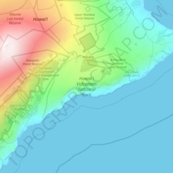
Nom : Carte topographique Hawai'i Volcanoes National Park, altitude, relief.
Altitude moyenne : 688 m
Altitude minimum : 0 m
Altitude maximum : 4 163 m
Autres cartes topographiques
Cliquez sur une carte pour visualiser sa topographie, son altitude et son relief.
Mauna Kea
United States of America (Island of Hawai'i territorial waters) > Hawaï > Hilo
Mauna Kea, Hilo, Hawaiʻi County, Hawaï, United States of America (Island of Hawai'i territorial waters)
Altitude moyenne : 3 979 m