
Carte topographique The Bronx
Carte interactive
Cliquez sur la carte pour afficher l’altitude.
À propos de cette carte
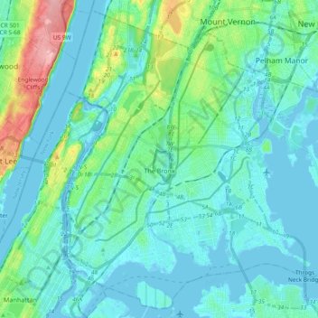
Nom : Carte topographique The Bronx, altitude, relief.
Lieu : The Bronx, New York, United States (40.78574 -73.93391 40.91763 -73.74837)
Altitude moyenne : 23 m
Altitude minimum : -9 m
Altitude maximum : 139 m
The Bronx's highest elevation at 280 feet (85 m) is in the northwest corner, west of Van Cortlandt Park and in the Chapel Farm area near the Riverdale Country School. The opposite (southeastern) side of the Bronx has four large low peninsulas or "necks" of low-lying land that jut into the waters of the East River and were once salt marsh: Hunt's Point, Clason's Point, Screvin's Neck and Throggs Neck. Further up the coastline, Rodman's Neck lies between Pelham Bay Park in the northeast and City Island. The Bronx's irregular shoreline extends for 75 square miles (194 km2).
Autres cartes topographiques
Cliquez sur une carte pour visualiser sa topographie, son altitude et son relief.
Staten Island
United States > New York > New York
Staten Island, Richmond County, New York, United States
Altitude moyenne : 9 m
Brooklyn
United States > New York > New York
Brooklyn, Kings County, New York, United States
Altitude moyenne : 9 m
Mill Pond Park
United States > New York > New York
Mill Pond Park, Bronx County, The Bronx, New York, United States
Altitude moyenne : 18 m
Manhattan Island
United States > New York > New York
Manhattan Island, New York, United States
Altitude moyenne : 17 m
Upper West Side
United States > New York > New York
Upper West Side, Manhattan Community Board 7, Manhattan, New York County, New York, United States
Altitude moyenne : 23 m
Freshkills Park
United States > New York > New York
Freshkills Park, Veterans Road West, Rossville, Staten Island, Richmond County, New York, 10309, United States
Altitude moyenne : 11 m
Starlight Park
United States > New York > New York
Starlight Park, Bronx County, The Bronx, New York, United States
Altitude moyenne : 17 m
Washington Heights
United States > New York > New York
Washington Heights, Manhattan Community Board 12, Manhattan, New York County, New York, United States
Altitude moyenne : 25 m
New York County
United States > New York > New York
New York County, New York, United States
Altitude moyenne : 16 m
Fort Greene Park
United States > New York > New York
Fort Greene Park, Fort Greene, Kings County, New York, United States
Altitude moyenne : 17 m
Bronx Park
United States > New York > New York
Bronx Park, New York, United States
Altitude moyenne : 30 m
Gowanus Canal
United States > New York > New York
Gowanus Canal, Kings County, New York, United States
Altitude moyenne : 11 m
Kings County
United States > New York > New York
Kings County, New York, United States, Marine Park
Altitude moyenne : 4 m
Todt Hill
United States > New York > New York
Todt Hill, Richmond County, New York, 10304, United States
Altitude moyenne : 50 m
Flushing Meadows-Corona Park
United States > New York > New York
Flushing Meadows-Corona Park, New York, United States
Altitude moyenne : 15 m
Kissena Park
United States > New York > New York
Kissena Park, Queens County, New York, United States
Altitude moyenne : 16 m
Queens County
United States > New York > New York
Queens County, New York, United States
Altitude moyenne : 11 m
Hart Island
United States > New York > New York
Hart Island, New York, United States
Altitude moyenne : 1 m
Coney Island Creek Park
United States > New York > New York
Coney Island Creek Park, Coney Island, Kings County, New York, United States
Altitude moyenne : 2 m
Jerome Park Reservoir
United States > New York > New York
Jerome Park Reservoir, The Bronx, New York, United States
Altitude moyenne : 35 m
Bronx County
United States > New York > New York
Bronx County, The Bronx, New York, United States
Altitude moyenne : 21 m
McCarren Park
United States > New York > New York
McCarren Park, Kings County, New York, United States
Altitude moyenne : 7 m
Prospect Park
United States > New York > New York
Prospect Park, Kings County, New York, United States
Altitude moyenne : 34 m
Jamaica Bay
United States > New York > New York
Jamaica Bay, Queens, New York, 11693, United States
Altitude moyenne : 0 m
Highland Park
United States > New York > New York
Highland Park, Queens County, New York, United States
Altitude moyenne : 28 m
Todt Hill
United States > New York > New York
Todt Hill, New York, 10304, United States
Altitude moyenne : 75 m
City Island
United States > New York > New York
City Island, The Bronx, New York, 10464, United States
Altitude moyenne : 1 m
Jackie Robinson Park
United States > New York > New York
Jackie Robinson Park, Brooklyn, Kings County, New York, United States
Altitude moyenne : 22 m
Forest Park
United States > New York > New York
Forest Park, New York, United States
Altitude moyenne : 25 m
Shore Road Park
United States > New York > New York
Shore Road Park, Brooklyn, New York, United States
Altitude moyenne : 9 m
Main Street Park
United States > New York > New York
Main Street Park, Brooklyn, Kings County, New York, United States
Altitude moyenne : 11 m
Kings County
United States > New York > New York
Kings County, New York, United States
Altitude moyenne : 9 m
Arbutus Lake
United States > New York > New York
Arbutus Lake, Staten Island, New York, United States
Altitude moyenne : 9 m
Middleton Playground
United States > New York > New York
Middleton Playground, Brooklyn, Kings County, New York, United States
Altitude moyenne : 13 m
Soundview Park
United States > New York > New York
Soundview Park, New York, United States
Altitude moyenne : 6 m
Richmond County
United States > New York > New York
Richmond County, New York, United States
Altitude moyenne : 9 m