
Carte topographique Yulchung
Carte interactive
Cliquez sur la carte pour afficher l’altitude.
À propos de cette carte
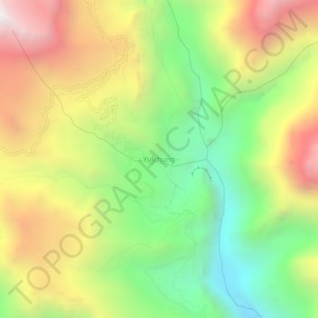
Nom : Carte topographique Yulchung, altitude, relief.
Lieu : Yulchung, Khalsi tehsil, Leh district, Ladakh, India (33.90699 76.89055 33.94699 76.93055)
Altitude moyenne : 4 224 m
Altitude minimum : 3 471 m
Altitude maximum : 5 128 m
Autres cartes topographiques
Cliquez sur une carte pour visualiser sa topographie, son altitude et son relief.
Ursi
India > Ladakh > Khalsi tehsil
Ursi, Khalsi tehsil, Leh District, Ladakh, India
Altitude moyenne : 3 941 m
Lingshed
India > Ladakh > Khalsi tehsil
Lingshed, Khalsi tehsil, Leh District, Ladakh, India
Altitude moyenne : 4 209 m
Debring
India > Ladakh > Khalsi tehsil
Debring, Khalsi tehsil, Leh District, Ladakh, India
Altitude moyenne : 4 380 m
Lamayuru
India > Ladakh > Khalsi tehsil
Lamayuru, Khalsi tehsil, Leh district, Ladakh, India
Altitude moyenne : 3 691 m