
Carte topographique Tirunelveli
Carte interactive
Cliquez sur la carte pour afficher l’altitude.
À propos de cette carte
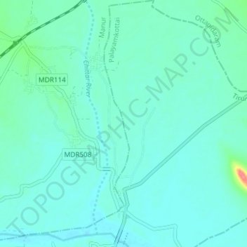
Nom : Carte topographique Tirunelveli, altitude, relief.
Altitude moyenne : 34 m
Altitude minimum : 24 m
Altitude maximum : 91 m
Tirunelveli is located at 8°43′41.82″N 77°41′43.94″E / 8.7282833°N 77.6955389°E / 8.7282833; 77.6955389, and its average elevation is 47 metres (154 ft). It is located at the southernmost tip of the Deccan plateau. The Tamirabarani River divides the city into the Tirunelveli quarter and the Palayamkottai area. The river (with its tributaries, such as the Chittar) is the major source of irrigation, and is fed by the northeast and southwest monsoons. The major lakes in the city are Nainar Lake and Udayarpetti Lake. The area around the Tamirabarani River and the Chittar has five streams: Kodagan, Palayan, Tirunelveli, Marudur East and Marudur West, and the Chittar feeds fifteen other channels. The soil is friable, red and sandy.
Autres cartes topographiques
Cliquez sur une carte pour visualiser sa topographie, son altitude et son relief.
Thamirabharani
India > Tamil Nadu > Tirunelveli
Thamirabharani, Tirunelveli, Tirunelveli District, Tamil Nadu, 627001, India
Altitude moyenne : 35 m
Tirunelveli
India > Tamil Nadu > Tirunelveli
Tirunelveli, Tirunelveli Kattabo, Tamil Nadu, India
Altitude moyenne : 65 m