Géolocaliser

Carte topographique Thiruvananthapuram

Carte interactive

Cliquez sur la carte pour afficher l’altitude.

À propos de cette carte

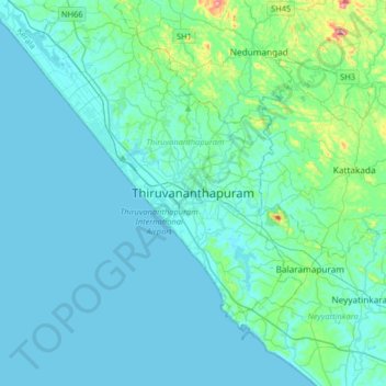
Nom : Carte topographique Thiruvananthapuram, altitude, relief.

Lieu : Thiruvananthapuram, Thiruvananthapuram District, Kerala, 695001, India (8.32823 76.78755 8.64823 77.10755)

Altitude moyenne : 33 m

Altitude minimum : -1 m

Altitude maximum : 316 m

Thiruvananthapuram is built on seven hills by the seashore and is at 8°30′N 76°54′E / 8.5°N 76.9°E / 8.5; 76.9 on the west coast, near the southern tip of mainland India. The city is on the west coast of India and is bounded by the Laccadive Sea to its west and the Western Ghats to its east. The average elevation of the city is 16 ft (4.9 m) above sea level. The Geological Survey of India has identified Thiruvananthapuram as a moderately earthquake-prone urban centre and categorised the metropolis in the Seismic III Zone. Thiruvananthapuram lies on the shores of Karamana and Killi rivers. Vellayani, Thiruvallam and Aakulam backwaters lie in the city. The soil type in the middle part of the city is a dark brown loamy laterite soil high in phosphates. Laterisation is a result of the heavy rainfall and humid conditions. In western coastal regions of the city, sandy loam soil is found, and on hilly eastern parts of the district, rich dark brown loam of granite origin is found.

Wikipedia (CC-BY-SA 3.0)

Autres cartes topographiques

Cliquez sur une carte pour visualiser sa topographie, son altitude et son relief.

Kadinamkulam

India > Kerala > Thiruvananthapuram > Puthenthope

Kadinamkulam, Puthenthope, Thiruvananthapuram, Thiruvananthapuram District, Kerala, India

Altitude moyenne : 10 m

Kuravankonam

India > Kerala > Thiruvananthapuram > Thiruvananthapuram

Kuravankonam, Kowdiar, Thiruvananthapuram, Thiruvananthapuram District, Kerala, 695001, India

Altitude moyenne : 36 m

Kumizhi kulam

India > Kerala > Thiruvananthapuram > Thiruvananthapuram

Kumizhi kulam, Kazhakkoottam, Thiruvananthapuram, Kerala, 695001, India

Altitude moyenne : 25 m

Kaniyapuram

India > Kerala > Thiruvananthapuram

Kaniyapuram, Thiruvananthapuram, Kerala, 695301, India

Altitude moyenne : 15 m

Aakulam park

India > Kerala > Thiruvananthapuram > Thiruvananthapuram

Aakulam park, Paruthippara, Thiruvananthapuram, Kerala, 695001, India

Altitude moyenne : 37 m

Kovalam

India > Kerala > Thiruvananthapuram

Kovalam, Thiruvananthapuram, Kerala, 695527, India

Altitude moyenne : 24 m

Karamana River

India > Kerala > Thiruvananthapuram > Thiruvananthapuram

Karamana River, Thiruvananthapuram, Kerala, 695001, India

Altitude moyenne : 50 m

Mangalapuram

India > Kerala > Thiruvananthapuram

Mangalapuram, Thiruvananthapuram, Kerala, 695317, India

Altitude moyenne : 33 m

Mannanthala

India > Kerala > Thiruvananthapuram > Mannanthala

Mannanthala, Thiruvananthapuram, Kerala, 695003, India

Altitude moyenne : 51 m