
Carte topographique Rajamahendravaram
Carte interactive
Cliquez sur la carte pour afficher l’altitude.
À propos de cette carte
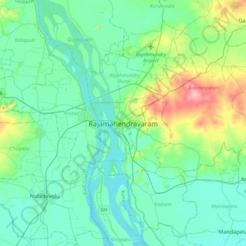
Nom : Carte topographique Rajamahendravaram, altitude, relief.
Altitude moyenne : 29 m
Altitude minimum : 4 m
Altitude maximum : 130 m
Rajahmundry is located at 16°59′N 81°47′E / 16.98°N 81.78°E / 16.98; 81.78. with an average elevation of 14 metres (46 ft). It is geographically located at centre of Godavari Districts.There is paddy, sugarcane and various varieties of flowers cultivation in the area. River Godavari flows through the west of Rajahmundry.