
Carte topographique Rhode Island
Carte interactive
Cliquez sur la carte pour afficher l’altitude.
À propos de cette carte
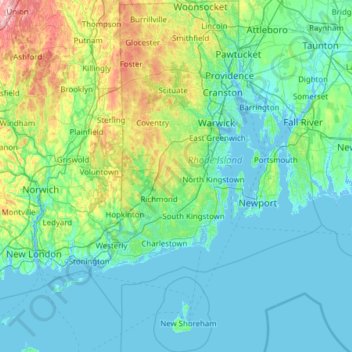
Nom : Carte topographique Rhode Island, altitude, relief.
Lieu : Rhode Island, United States (41.09583 -71.90743 42.01894 -71.08857)
Altitude moyenne : 53 m
Altitude minimum : -8 m
Altitude maximum : 393 m
Rhode Island covers an area of 1,214 square miles (3,144 km2) within the New England region of the Northeastern United States and is bordered on the north and east by Massachusetts, on the west by Connecticut, and on the south by Rhode Island Sound and the Atlantic Ocean. It shares a narrow maritime border with New York State between Block Island and Long Island. The state's mean elevation is 200 feet (61 m). It is only 37 miles (60 km) wide and 48 miles (77 km) long, yet the state has a tidal shoreline on Narragansett Bay and the Atlantic Ocean of 384 miles (618 km).
Autres cartes topographiques
Cliquez sur une carte pour visualiser sa topographie, son altitude et son relief.
Houston
United States > Texas > Harris County
Houston, Harris County, Texas, United States
Altitude moyenne : 25 m
Brunswick County
United States > North Carolina
Brunswick County, North Carolina, United States
Altitude moyenne : 9 m
Appalachian Mountains
United States > North Carolina > Yancey County
Appalachian Mountains, Yancey County, North Carolina, United States
Altitude moyenne : 1 463 m
Brooklyn
United States > New York > New York
Brooklyn, Kings County, New York, United States
Altitude moyenne : 9 m
Albuquerque
United States > New Mexico > Bernalillo County
Albuquerque, Bernalillo County, New Mexico, United States
Altitude moyenne : 1 688 m
Santa Cruz
United States > California > Santa Cruz County
Santa Cruz, Santa Cruz County, California, United States
Altitude moyenne : 89 m
Boulder
United States > Colorado > Boulder County
Boulder, Boulder County, Colorado, United States
Altitude moyenne : 1 785 m
Yakima County
Yakima County, Washington, United States
Altitude moyenne : 879 m
Manhattan
United States > New York > New York County > New York
Manhattan, New York County, New York, United States
Altitude moyenne : 16 m
Palm Springs
United States > California > Riverside County
Palm Springs, Riverside County, California, United States
Altitude moyenne : 859 m
Safety Harbor
United States > Florida > Pinellas County
Safety Harbor, Pinellas County, Florida, 34695, United States
Altitude moyenne : 11 m
New Haven
United States > Connecticut > New Haven County > New Haven
New Haven, New Haven County, Connecticut, United States
Altitude moyenne : 22 m
Arlington
United States > Massachusetts > Middlesex County
Arlington, Middlesex County, Massachusetts, United States
Altitude moyenne : 35 m
Whatcom County
Whatcom County, Washington, United States
Altitude moyenne : 753 m
Central Park
United States > New York > New York County > New York
Central Park, New York County, New York, United States
Altitude moyenne : 26 m
Corpus Christi
United States > Texas > Nueces County
Corpus Christi, Nueces County, Texas, United States
Altitude moyenne : 8 m
Boston
United States > Massachusetts > Suffolk County
Boston, Suffolk County, Massachusetts, United States
Altitude moyenne : 25 m
Cambridge
United States > Massachusetts > Middlesex County
Cambridge, Middlesex County, Massachusetts, United States
Altitude moyenne : 11 m
New Orleans
United States > Louisiana > Orleans Parish
New Orleans, Orleans Parish, Louisiana, United States
Altitude moyenne : 1 m
Fresno
United States > California > Fresno County
Fresno, Fresno County, California, United States
Altitude moyenne : 98 m