
Carte topographique Erzurum
Carte interactive
Cliquez sur la carte pour afficher l’altitude.
Erzurum
Située à 1 945 mètres d'altitude sur le haut-plateau arménien, cette ville du nord-est de la Turquie est une des plus hautes de la région. La ville se trouve dans une plaine parsemée de quelques collines de roches volcaniques dont la plus élevée porte la citadelle.
À propos de cette carte
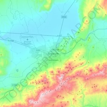
Nom : Carte topographique Erzurum, altitude, relief.
Altitude moyenne : 2 089 m
Altitude minimum : 1 750 m
Altitude maximum : 3 166 m