
Carte topographique South East England
Carte interactive
Cliquez sur la carte pour afficher l’altitude.
À propos de cette carte
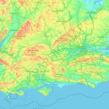
Nom : Carte topographique South East England, altitude, relief.
Lieu : South East England, England, United Kingdom (50.57468 -1.95728 52.19632 1.45177)
Altitude moyenne : 69 m
Altitude minimum : -3 m
Altitude maximum : 491 m
Near Weybridge are the UK headquarters of Sony with SSP Group (situated in Byfleet) and Procter & Gamble (next door to each other on The Heights Business Park near the former Brooklands racing circuit) with Kia Motors UK and Petroleum Geo-Services UK, and Gallaher Group (cigarettes) is to the north, next to the Brooklands Museum; to the east is Verint Systems UK on the B374. In Weybridge are the local newspaper group Newsquest, Yamaha Motors UK; BAE Systems Regional Aircraft is on the Brooklands Ind Park off the A318 (since 2001 it has no longer manufactured). On Sprint Ind Est in Byfleet, west of Weybridge, off the A318, AIM Altitude (former Henshalls) make cabin galleys for airliners. The Central Veterinary Laboratory, which is run by the Veterinary Laboratories Agency, with the Animal and Plant Health Agency, is in New Haw to the west on the other side of the M25. Mouchel is in West Byfleet.
Autres cartes topographiques
Cliquez sur une carte pour visualiser sa topographie, son altitude et son relief.
London
United Kingdom > England > London
London, Greater London, England, SW1A 2DX, United Kingdom
Altitude moyenne : 42 m
Birmingham
Birmingham, West Midlands Combined Authority, England, United Kingdom
Altitude moyenne : 138 m
Bristol
United Kingdom > England > City of Bristol
Bristol, City of Bristol, West of England, England, United Kingdom
Altitude moyenne : 55 m
Newcastle upon Tyne
Newcastle upon Tyne, North of Tyne, England, United Kingdom
Altitude moyenne : 57 m
Clapham Common
United Kingdom > England > London
Clapham Common, Balham, London Borough of Wandsworth, London, Greater London, England, United Kingdom
Altitude moyenne : 22 m
Greater Manchester
Greater Manchester, England, United Kingdom
Altitude moyenne : 141 m
Richmond
United Kingdom > England > London
Richmond, London, Greater London, England, TW9 1DY, United Kingdom
Altitude moyenne : 17 m
Sheffield
Sheffield, South Yorkshire, England, United Kingdom
Altitude moyenne : 168 m
Liverpool
Liverpool, Liverpool City Region, England, United Kingdom
Altitude moyenne : 26 m
East Riding of Yorkshire
East Riding of Yorkshire, England, United Kingdom
Altitude moyenne : 30 m
Bath
United Kingdom > England > Bath and North East Somerset
Bath, Bath and North East Somerset, West of England, England, United Kingdom
Altitude moyenne : 100 m
Chesterfield
United Kingdom > England > Derbyshire
Chesterfield, Derbyshire, England, United Kingdom
Altitude moyenne : 127 m
Cambridge
United Kingdom > England > Cambridgeshire
Cambridge, Cambridgeshire, Cambridgeshire and Peterborough, England, United Kingdom
Altitude moyenne : 18 m
City of Bristol
City of Bristol, West of England, England, United Kingdom
Altitude moyenne : 80 m
Hampstead Heath
United Kingdom > England > London
Hampstead Heath, Gospel Oak, London Borough of Camden, London, Greater London, England, United Kingdom
Altitude moyenne : 94 m
London
London, Greater London, England, United Kingdom
Altitude moyenne : 66 m
West Midlands
United Kingdom > England > Warwickshire
West Midlands, Warwickshire, West Midlands Combined Authority, England, United Kingdom
Altitude moyenne : 113 m
Tonbridge
United Kingdom > England > Kent > Tonbridge and Malling
Tonbridge, Tonbridge and Malling, Kent, England, TN9 2AN, United Kingdom
Altitude moyenne : 55 m
Norwich
United Kingdom > England > Norfolk
Norwich, Norfolk, England, United Kingdom
Altitude moyenne : 28 m
Bournemouth
United Kingdom > England > Bournemouth, Christchurch and Poole > Wick
Bournemouth, Wick, Bournemouth, Christchurch and Poole, England, United Kingdom
Altitude moyenne : 17 m
Kingston
United Kingdom > England > Dorset
Kingston, Corfe Castle, Dorset, England, BH20 5LH, United Kingdom
Altitude moyenne : 86 m
Redditch
United Kingdom > England > Worcestershire
Redditch, Worcestershire, England, United Kingdom
Altitude moyenne : 99 m
Oxford
United Kingdom > England > Oxfordshire
Oxford, Oxfordshire, England, United Kingdom
Altitude moyenne : 81 m
Cambridge
United Kingdom > England > Cambridge
Cambridge, Cambridgeshire, East of England, England, United Kingdom
Altitude moyenne : 18 m
Guildford
United Kingdom > England > Surrey
Guildford, Surrey, England, United Kingdom
Altitude moyenne : 74 m
West Yorkshire
West Yorkshire, England, United Kingdom
Altitude moyenne : 172 m
Richmond Park
United Kingdom > England > London
Richmond Park, London Borough of Richmond upon Thames, London, Greater London, England, United Kingdom
Altitude moyenne : 26 m
Dartmoor National Park
United Kingdom > England > Devon
Dartmoor National Park, Devon, England, United Kingdom
Altitude moyenne : 239 m
Somerset
Somerset, South West England, England, United Kingdom
Altitude moyenne : 87 m
Greater London
Greater London, England, United Kingdom
Altitude moyenne : 66 m
Coventry
Coventry, West Midlands Combined Authority, England, United Kingdom
Altitude moyenne : 99 m
Finghall
United Kingdom > England > North Yorkshire
Finghall, North Yorkshire, England, DL8 5NB, United Kingdom
Altitude moyenne : 126 m
Askham Richard
United Kingdom > England > York
Askham Richard, York, England, United Kingdom
Altitude moyenne : 27 m
River Yeo
United Kingdom > England > Somerset > Ilchester
River Yeo, Ilchester, Somerset, England, United Kingdom
Altitude moyenne : 40 m
Bricket Wood
United Kingdom > England > Hertfordshire > St Albans
Bricket Wood, St Albans, Hertfordshire, England, AL2 3QS, United Kingdom
Altitude moyenne : 82 m
Leeds
United Kingdom > England > Leeds
Leeds, Yorkshire and the Humber, England, LS1 6AL, United Kingdom
Altitude moyenne : 94 m
Buxton
United Kingdom > England > Derbyshire > High Peak
Buxton, High Peak, Derbyshire, England, United Kingdom
Altitude moyenne : 334 m