
Carte topographique Bloomington
Carte interactive
Cliquez sur la carte pour afficher l’altitude.
À propos de cette carte
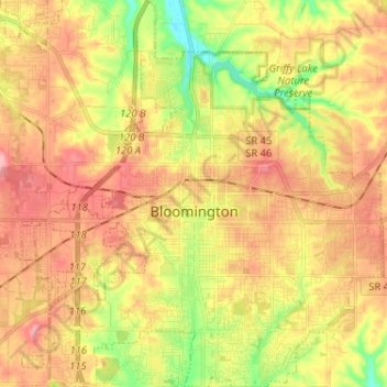
Nom : Carte topographique Bloomington, altitude, relief.
Lieu : Bloomington, Monroe County, Indiana, United States (39.12133 -86.59189 39.22136 -86.47113)
Altitude moyenne : 241 m
Altitude minimum : 177 m
Altitude maximum : 293 m
Bloomington is an area of irregular limestone terrain characterized by sinks, ravines, fissures, underground streams, sinking streams, springs and caves. It is in the rolling hills of southern Indiana, resting on the intersection of the Norman Uplands and the Mitchell Plain. The city's relatively varied topography is a sharp contrast to the flatter terrain more typical of central to northern portions of Indiana.
Autres cartes topographiques
Cliquez sur une carte pour visualiser sa topographie, son altitude et son relief.
Clear Creek
United States > Indiana > Monroe County > Clear Creek
Clear Creek, Monroe County, Indiana, United States
Altitude moyenne : 218 m
University Lake Dam
United States > Indiana > Monroe County > Bloomington
University Lake Dam, Bloomington, Monroe County, Indiana, 47408, United States
Altitude moyenne : 236 m
Upper Cascades Park
United States > Indiana > Monroe County > Bloomington
Upper Cascades Park, Bloomington, Monroe County, Indiana, United States
Altitude moyenne : 217 m
Ellettsville
United States > Indiana > Monroe County
Ellettsville, Monroe County, Indiana, United States
Altitude moyenne : 235 m
Broadview
United States > Indiana > Monroe County > Bloomington
Broadview, Bloomington, Monroe County, Indiana, 47402, United States
Altitude moyenne : 231 m