
Carte topographique St. Marys
Carte interactive
Cliquez sur la carte pour afficher l’altitude.
À propos de cette carte
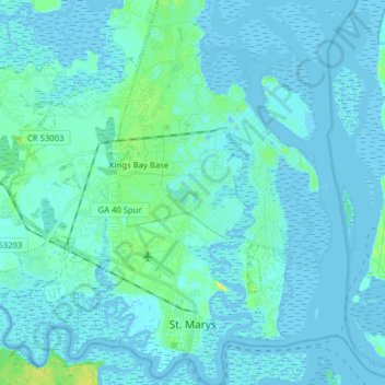
Nom : Carte topographique St. Marys, altitude, relief.
Lieu : St. Marys, Camden County, Georgia, United States (30.70904 -81.65818 30.84418 -81.50552)
Altitude moyenne : 3 m
Altitude minimum : -7 m
Altitude maximum : 21 m
Autres cartes topographiques
Cliquez sur une carte pour visualiser sa topographie, son altitude et son relief.
Kingsland
United States > Georgia > Camden County
Kingsland, Camden County, Georgia, 31548, United States
Altitude moyenne : 5 m
London Hill
United States > Georgia > Camden County
London Hill, Camden County, Georgia, United States
Altitude moyenne : 2 m
Woodbine
United States > Georgia > Camden County
Woodbine, Camden County, Georgia, United States
Altitude moyenne : 6 m
Kings Bay Base
United States > Georgia > Camden County
Kings Bay Base, Camden County, Georgia, 31558, United States
Altitude moyenne : 6 m
Satilla River
United States > Georgia > Camden County
Satilla River, Camden County, Georgia, 31568, United States
Altitude moyenne : 4 m
Cumberland Island
United States > Georgia > Camden County
Cumberland Island, Camden County, Georgia, United States
Altitude moyenne : 2 m
Crooked River Plantation
United States > Georgia > Camden County > St. Marys > Crooked River Plantation
Crooked River Plantation, St. Marys, Camden County, Georgia, 31547, United States
Altitude moyenne : 5 m
State of Georgia
United States > Georgia > Camden County > Kingsland
State of Georgia, Kingsland, Camden County, Georgia, United States
Altitude moyenne : 5 m
Tarboro
United States > Georgia > Camden County > Tarboro
Tarboro, Camden County, Georgia, 31568, United States
Altitude moyenne : 5 m
White Oak
United States > Georgia > Camden County > White Oak
White Oak, Camden County, Georgia, United States
Altitude moyenne : 6 m